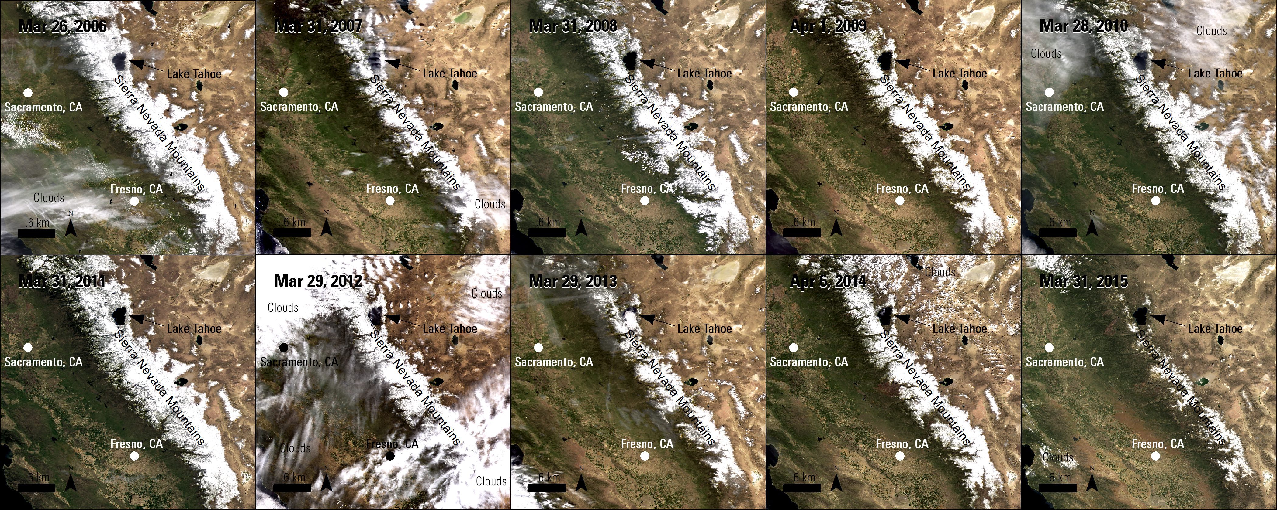
California is in its fourth consecutive year of drought, which impacts water in the state in many ways. The main sources of consumable and agricultural water for California are underground aquifers, reservoirs and mountain snowpacks, but in recent years the volume of water in these sources has been decreasing.
USGS Maps Human-Induced Land Changes
The U.S. Geological Survey released a Landsat-based report and dataset on anthropogenic land-use trends in the United States from 1974-2012. The time periods coincide with U.S. Department of Agriculture (USDA) Census of Agriculture data-collection years.
Military Drone Market to Reach $10 billion by 2024
The market for military drones is expected to nearly double by 2024 to more than $10 billion, according to a report published by IHS Jane's Intelligence Review.
UAVs Help Nepal Towns Build Back Better, Faster
The Humanitarian UAV Network, which seeks to enable the safe, responsible and effective use of unmanned aerial vehicles (UAVs) in humanitarian and development settings, led a mission in Nepal in collaboration with Kathmandu University, Kathmandu Living Labs, DJI and Pix4D.
Hurricane Joaquin Pictured from International Space Station
Hurricane Joaquin, the strongest Atlantic hurricane of the 2015 season, is shown in this photograph taken by NASA Astronaut Scott Kelly on Oct. 2, 2015, from the International Space Station.
21AT Releases First Images from TripleSat Constellation
Twenty First Century Aerospace Technology Co. (21AT) released the first in-orbit images acquired from its recently launched TripleSat Constellation of three identical optical satellites.
Professor Using Airborne LiDAR to Identify Tree Genus
Professor Benoît St-Onge of the Université du Québec à Montréal is using airborne multispectral LiDAR data to identify trees by genus.
exactEarth Launches Equatorial AIS Satellite
exactEarth Ltd. announced the successful launch on Sept. 28, 2015, of its exactView-9 (EV9) automatic identification system (AIS) satellite, expanding its global vessel-monitoring constellation to eight in-orbit satellites.
Satellite Firm Gets $1 Million State Loan
Toledo-based Blue Water Satellite Inc., which uses satellite data to provide high-accuracy measurements of water and soil conditions, received a $1 million loan from the state of Ohio.
U.S. Using Satellite Data to Map Alaska, Arctic
The U.S. National Geospatial-Intelligence Agency, the National Science Foundation (NSF), and the University of Minnesota's Polar Geospatial Center are collaborating to use high-resolution satellite imagery from DigitalGlobe, processed with NSF-supported advanced computing resources, to produce improved, publicly available Digital Elevation Models of Alaska by mid-2016 and the entire Arctic by the end of 2016.