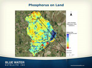
Blue Water Satellite uses imagery to identify chemicals and organic material in water. This image of Ohio's Choctaw Lake shows phosphorus pooling in the southern area.
Toledo-based Blue Water Satellite Inc., which uses satellite data to provide high-accuracy measurements of water and soil conditions, received a $1 million loan from the state of Ohio.
The company takes publicly available satellite data and runs them through a series of proprietary algorithms that identify the unique light spectrum reflected by different chemical compounds and organic matter. The process allows the company to measure heavy metals, phosphorus, temperatures and submerged aquatic vegetation, among other details.
In 2014, the company identified and measured the bacteria that made Toledo's water unsafe to drink.
Blue Water Satellite provides valuable information about our region's water supply, which can improve our ability to keep our drinking water clean and safe, said State Sen. Edna Brown (D., Toledo).

