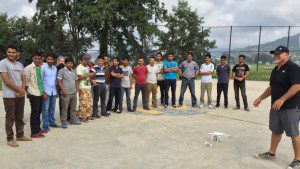
The Humanitarian UAV Network flew more than 60 UAV flights over a small town in Nepal to help it rebuild from the devastating earthquakes that hit the area earlier in 2015.
The Humanitarian UAV Network, which seeks to enable the safe, responsible and effective use of unmanned aerial vehicles (UAVs) in humanitarian and development settings, led a mission in Nepal in collaboration with Kathmandu University, Kathmandu Living Labs, DJI and Pix4D.
The group teamed with the Community Disaster Management Committee of Kirtipur to survey the town of Panga, which had been severely affected by the 2015 earthquake that rocked the country. High-resolution aerial imagery will be used to build back faster and better, so several UAVs were flown over the area in a short amount of time.
With more than 800 aerial photographs in hand, the Pix4D team produced a high-resolution orthorectified mosaic of Panga. Next, MicroMappers will be used to crowdsource the analysis and digital annotation of oblique aerial pictures and videos to develop automated feature-detection algorithms using techniques from computer vision and machine learning.
Read more here.

