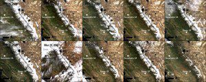
Ten Terra MODIS true-color surface-reflectance images of the Sierra Nevada mountains captured during spring between 2006-2015 allow researchers to observe and measure changes in snow levels. (Credit: NASA/USGS)
California is in its fourth consecutive year of drought, which impacts water in the state in many ways. The main sources of consumable and agricultural water for California are underground aquifers, reservoirs and mountain snowpacks, but in recent years the volume of water in these sources has been decreasing.
One of the contributing factors is a record decrease in the amount of snowfall during recent winters. Typically snowfall accumulates during the winter, forming snowpacks, which melt during the spring. This meltwater flows into streams, reservoirs and rivers. During years of normal precipitation, the California Department of Water Resources records melted snowpack as providing approximately 30 percent of California's water supply. However, the recent amount of snowfall has limited this source of water.
According to scientists, the snow water equivalent (SWE) in the Sierra Nevada mountains in 2015 was at 5 percent of its historical average.

