Astronauts Eye Lake Powell and the Rincon

Astronauts Eye Lake Powell and the Rincon

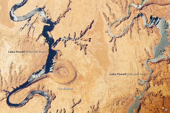
This astronaut photograph highlights part of Lake Powell. Looking somewhat like a donut or automobile tire from the vantage point of the International Space Station, the Rincon (image center) is an entrenched and abandoned meander, or loop, of the Colorado River.

Dry Lake Area Resembles Painter's Palette

Dry Lake Area Resembles Painter's Palette

This astronaut photograph shows the white, salt-covered floor in the northwest corner of the Etosha Pan, a great dry lake in northern Namibia, surrounded by multicolored water features. In a rare event shown in this image, rainwater has flowed down the Ekuma River”which appears as a blue line within the light gray-green floodplain”and fills a lobe of the lake with light green water.

Astronauts Photograph Algerian Meteor Crater

Astronauts Photograph Algerian Meteor Crater

From the vantage point of an astronaut on the International Space Station, the Ouarkziz Impact Crater, located in northwestern Algeria close to the Moroccan border, is clearly visible with a magnifying camera lens.

Sunny Skies Over Antarctica

Sunny Skies Over Antarctica

Sunny skies and westerly winds prevailed over the Antarctic Peninsula on April 24, 2012. Cloudy weather had just moved out, and temperatures rose well above freezing as the MODIS sensor on NASA's Terra satellite passed overhead and captured a natural-color image.

Island Summit Induces Wave Clouds

Island Summit Induces Wave Clouds

This astronaut photograph illustrates the formation of wave clouds in the wake, or downwind side, of ÃŽle aux Cochons, often called Pig Island, in the southern Indian Ocean. The island's summit elevation is high enough to interact with cloud layers and flowing winds. Once air masses pass over the summit, they descend and may encounter alternating moist and dry air layers, enabling the formation of the discontinuous, chevron-shaped wave clouds.

Giant Stripes Adorn African Strip

Giant Stripes Adorn African Strip

In far northeastern Namibia, there's a skinny stretch of land sandwiched between Angola, Botswana and Zambia where the land is striped, as if a giant had dragged a rake over the landscape. On Feb. 1, 2012, the Advanced Land Imager on NASA's Earth Observing-1 satellite captured this natural-color image of the Caprivi Strip just north of the Okavango River.

Giant Fog Patch Hovers Over Yellow Sea

Giant Fog Patch Hovers Over Yellow Sea

In spring, it's not uncommon for a cloak of thick fog to cover the Yellow Sea. The shallow sea, which has a number of busy ports, usually sees 50 foggy days a year, but some weather stations in the area have measured as many as 80 days. One of those days was March 28, 2012, when the Moderate Resolution Imaging Spectroradiometer (MODIS) sensor on NASA's Aqua satellite captured this natural-color image of a fog bank hugging the Korean coast.

East African Rift Valley a Geologic Maze

East African Rift Valley a Geologic Maze

The East African Rift, caused by fracturing of Earth's crust, is one of the great tectonic features of Africa. This astronaut photograph of the Eastern Branch of the Rift near Kenya's southern border highlights the classical geologic structures associated with a tectonic rift valley.

Pacific Island Blows off Steam

Pacific Island Blows off Steam

A steam plume blows south from the peak of Pagan Island's northernmost volcano in this photograph by an astronaut on the International Space Station (ISS). The ISS was located over the Pacific Ocean approximately 480 kilometers to the southeast of Pagan Island when the image was acquired on March 6, 2012.

NEWEST V1 MEDIA PUBLICATION

April Issue 2024