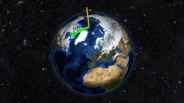
Using satellite data on how water moves around Earth, NASA scientists solved two mysteries about wobbles in the planet’s rotation. Earth's spin axis drifts slowly around the poles; the farthest away it has wobbled since observations began is 37 feet (12 meters). These wobbles don't affect daily life, but they must be taken into account to get accurate results from GPS, Earth-observing satellites and ground-based observatories.
European/Australian Partnership to Provide Satellite Data Hub
The European Space Agency (ESA) and Australia's national geological survey, Geoscience Australia (GA), partnered to ensure data from EU's Sentinel satellites are accessible in Southeast Asia and the South Pacific.
Free Report Examines UASs in Precision Agriculture
The Commercial UAV Expo published a free report, UAVs in Precision Agriculture, which describes how drone/UAS/UAV technology is reshaping how farmers and growers perform crop scouting, nutrient management, field mapping, drainage assessment and more.
SkyTruth Tracking Poachers in Palau via Satellites
An article in the New York Times Magazine chronicles how data analysts, the government of Palau and a nonprofit organization called SkyTruth are using satellite data to fight fishing poachers in the nation made up of 250 separate islands.
Cloud-Seeding UAS Successfully Tested in Nevada
A team of Nevada scientists and unmanned aircraft system (UAS) engineers successfully flight tested the first-ever autonomous cloud-seeding aircraft platform.
Atmospheric River Storms Can Reduce Sierra Snow
A new study by NASA and several partners found that in California's Sierra Nevada, atmospheric river storms are two-and-a-half times more likely than other types of winter storms to result in destructive rain-on-snow events, where rain falls on existing snowpack, causing it to melt.
GEO Launches Early Warning Crop Monitor to Fight Food Insecurity
The Group on Earth Observations (GEO) introduced the Early Warning Crop Monitor (EWCM), a new tool that provides consensus reports on crop conditions in countries at risk of food insecurity in Central and South America, Africa, the Middle East, and Central and East Asia.
Despite Ban, Ozone-Eating Chemical Remains Prevalent
Carbon tetrachloride (CCl4), once commonly used as a cleaning agent, is a known air toxin that eats away at the ozone layer. Its production has been banned for many years, but a new CIRES and NOAA study reports those rates are still 30-100 times higher than amounts reported to emission inventories.
Landsat Satellite Spots Sunken Ships
Using data from the NASA/USGS Landsat 8 satellite, researchers have detected sediment plumes extending as far as four kilometers downstream from shallow shipwreck sites, demonstrating how satellites may be used to locate the watery graves of coastal shipwrecks.
Mediterranean Drought Worst in 900 Years
A new NASA study used remote-sensing and tree-ring data to conclude that the recent drought that began in 1998 in the eastern Mediterranean Levant region (Cyprus, Israel, Jordan, Lebanon, Palestine, Syria and Turkey) is likely the worst drought of the last nine centuries.