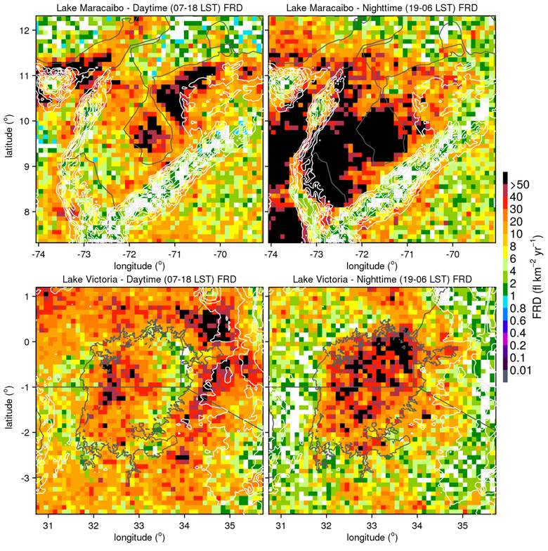
Satellite readings show that atmospheric methane and carbon dioxide are continuing to increase despite global efforts to reduce emissions. Methane concentrations were somewhat constant until 2007, but since then have increased about 0.3 percent per year, whereas global carbon dioxide levels continue to rise at about 0.5 percent per year.
NAAMES Mission Studies Oceans and Atmosphere
The North Atlantic Aerosols and Marine Ecosystems Study (NAAMES), a five-year NASA-funded study, is the first NASA Earth Venture-Suborbital mission focused on studying the coupled ocean ecosystem and atmosphere using ships and aircraft simultaneously.
Living Planet Symposium Begins in Prague
One of the largest Earth-observation conferences in the world began on May 9, 2016, as thousands of scientists from around the world gathered in the Czech Republic to present their latest findings on our changing planet.
Satellites Monitor Canada's Fort McMurray Wildfire
In early May 2016, a destructive wildfire burned through Canada's Fort McMurray in the Northern Alberta region, forcing the evacuation of more than 80,000 people.
Venezuela's Lake Maracaibo Wins Lightning Crown
Using data from the Lightning Imaging Sensor (LIS) onboard NASA's Tropical Rainfall Measurement Mission, a new study determined that Lake Maracaibo in Venezuela is the new lightning capital of the world.
Mobile Mapping App Capturing Bat Data in Africa
The Defense Threat Reduction Agency (DTRA), in conjunction with Colorado State University (CSU) and the Center of Disease Control (CDC), are funding a project to measure and monitor bats in Uganda. The bats are suspected of carrying pathogens in the area, and the catch-and-release program will record detailed measurements and statistics as part of ecological and bat-distribution research.
Second Sentinel Successfully Launched
The second satellite of the Sentinel-1 mission, Sentinel-1B, was successfully launched from Europe's Spaceport in French Guiana on April 22, 2016.
3D-Printed UAS Aiding Antarctic Navigation
A 3D-printed UAS built by the University of Southampton is helping the British Royal Navy's ice-patrol ship HMS Protector navigate through Antarctic seas.
Landsat Data Document Pavement Increase in D.C.
A study recently published in the Remote Sensing of Environment journal used Landsat data from 1984 and 2010 to show how paved surfaces in the Washington, D.C., area have increased dramatically.
Antarctic Icebergs Break Free
On April 7, 2016, multiple satellites captured the birth of two large icebergs that were shed along a crack on Antarctica's Nansen Ice Shelf during persistent strong offshore winds. The icebergs currently pose no threat to shipping, but they may pose a threat to scientific instruments moored to the seafloor to monitor climate change.