Image processing innovations are creating value for decision makers. By Robert Schowengerdt, professor emeritus, University of Arizona (http://www.arizona.edu/), Tucson, Ariz. He is the author of Remote Sensing—Models and Methods for Image Processing (2006), which...
Air Combat Command's GeoBase Mission
Advanced raster management speeds disaster response and other mission-critical data to U.S. Air Force operations worldwide. By Mike Cannon, Dave Williams and Matt Moore, AECOM (http://www.aecom.com/), Virginia Beach, Va. The U.S. Air Force (USAF) is divided into Major...
Immediate Awareness Immediate Response
New Web-based platforms for delivering satellite imagery and other critical geospatial information to first responders are revolutionizing disaster management. By Tara Byrnes, director, North American channel, GeoEye (http://www.geoeye.com/), Herndon, Va. Sometimes we...
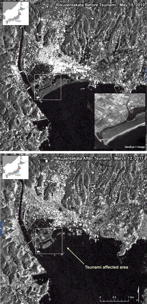
Disaster Response in JAPAN
Geospatial Community to the Rescue Following the devastating March 11, 2011, earthquake and tsunami that struck Japan, a host of geospatial companies provided pivotal disaster response information and services. Many of the same companies and more will contribute to...
Sensor Fusion Benefits Complex Coastal Mapping
By Molly Reif, Lauren Dunkin, Jennifer Wozencraft and Christopher Macon, U.S. Army Corps of Engineers, Joint Airborne LiDAR Bathymetry Technical Center of Expertise (www.jalbtcx.org), Kiln, Miss. Sensor fusion advancements are being used to develop and enhance...
Transforming the Geospatial Landscape: Creating a Common Level of Understanding with Technology, Policy and Programs
   Practically overnight, access to terabytes of geographical information, much of it in three dimensions, has changed the way people work, live and play. Now is the time to create a common level of understanding related to geospatial technology, policy and...
Homeland Security Challenges Create Geospatial Opportunities
By Michael F. Goodchild, Department of Geography, University of California, Santa Barbara (www.geog.ucsb.edu). Although traditional geospatial applications often have proceeded at a fairly leisurely pace, applications in emergency management almost always stress the...
Homeland Security Starts at Sea
By Guy Thomas, science and technology advisor, U.S. Coast Guard (www.uscg.mil), Washington, D.C. If oil is the world’s lifeblood, then oceanic commerce is its backbone. Since the 9/11 attack on the United States, many national and international organizations have...
Transportation Management: LiDAR, Satellite Imagery Expedite Infrastructure Planning
By Waheed Uddin, professor of civil engineering and director, Center for Advanced Infrastructure Technology (www.olemiss.edu/projects/cait), University of Mississippi, University, Miss. For years, transportation projects have benefitted from aerial photography and...
EARTH OBSERVING-1 Celebrates 10 Years of Innovation
By Holli Riebeek, NASA’s Earth Observatory, Goddard Space Flight Center (www.nasa.gov/centers/goddard), Greenbelt, Md. Scheduled to fly for a year and designed to last a year and a half, NASA’s Earth-Observing-1 satellite (EO-1) celebrated its 10th anniversary on...
