July 22, 2015 — Using Ordnance Survey’s unrivalled outdoors mapping it allows users to plot routes along public rights of way and footpaths. It is hoped the simple-to-use navigating tool will encourage even more people to explore the parks. The intelligent...
3DEP Data Acquisition Opportunity – FY15/16 Broad Agency Announcement
July 22, 2015 — On July 17, 2015, the USGS issued the FY15/FY16 Broad Agency Announcement (BAA) for 3D Elevation Program (3DEP). The BAA provides detailed information on how to partner with the USGS and other Federal agencies to acquire high-quality 3D Elevation...
eBee Becomes Canada's First Compliant Fixed-Wing Drone
Cheseaux-Lausanne, Switzerland / Canada, July 22, 2015 — Swiss professional drone manufacturer, senseFly, today announced that its eBee has become the first fixed-wing system to be designated a ‘compliant small UAV’ by Transport Canada—a distinction that...
Leica Geosystems, Esri Supercharge Mobile Data Collection with ZenoCollector
Norcross, Ga., USA/Redlands, Calif., USA, July 22, 2015 — The Leica Zeno 20, the ultra-rugged, Android-based and professional-grade handheld, has combined with Collector for ArcGIS, one of the most powerful and configurable field data collection apps in the world,...
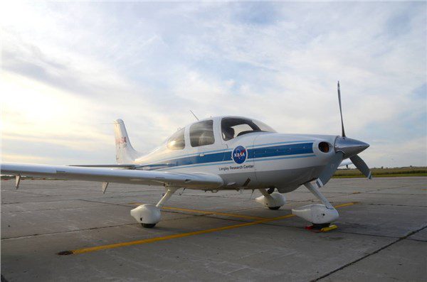
NASA Aircraft Assists in Drone Medical-Supply Delivery Research
Some underserved Virginia patients were among the first to be officially helped by an Unmanned Aircraft System (UAS), more commonly known as a drone, during research flights to a medical clinic in Wise County during July 2015.
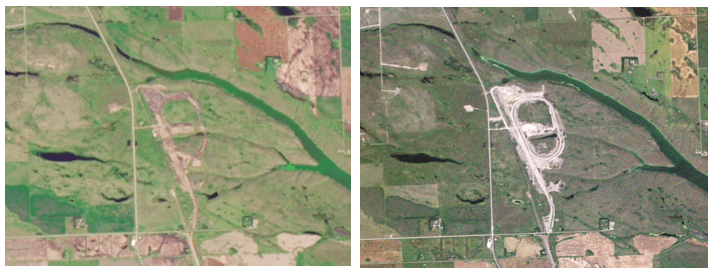
Planet Labs to Acquire BlackBridge
On July 15, 2015, BlackBridge, a provider of satellite imagery and geospatial solutions, entered a definitive agreement for Planet Labs to acquire the RapidEye suite of core offerings. Planet Labs designs, builds and operates a fleet of Earth-imaging satellites.
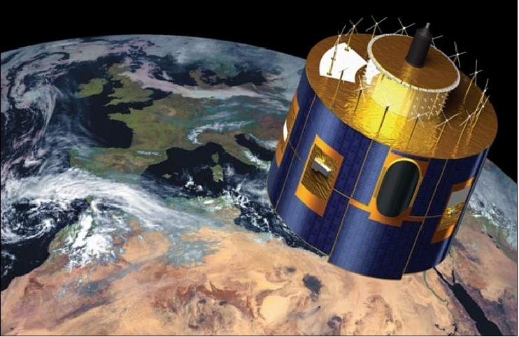
Next-Generation European Weather Satellite Launched
Europe successfully launched its next-generation Meteosat weather satellite on July 15, 2015, from Europe's Spaceport in Kourou, French Guiana. The MSG-4 will rise into geostationary orbit 36,000 kilometers above the equator, providing up-to-date weather coverage over Europe and Africa every 15 minutes, and rapid scan imagery over Europe every five minutes.
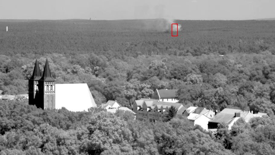
FireWatch Uses Space-Age Cameras
The German forest-fire detection effort has a new and more-effective input after installing a series of FireWatch cameras developed by the German Aerospace Center (DLR). More than 150 such cameras, based on technology used on space missions, have been installed in five German states.
Munich-Based Sensor Startup KONUX Announces Line of Optoelectronic Torque Sensors
MUNICH, July 21, 2015 -—Sensor startup KONUX announces optoelectronic sensors that set new industry standards of precision and robustness, enabling faster production and maximum asset utilization. In the field of collaborative robots, KONUX torque sensors ensure...
SuperGIS Server Extends Map Possibilities with Various Resources
July 21, 2015 — This week, Supergeo releases the latest version of SuperGIS Server with plenty of new functions, including related tables, improved JavaScript print tool, and new JavaScript APIs supporting OGC layers. With these new functions, users are able to...
