TORONTO, Sept. 8, 2014—Optech is pleased to announce that visitors to the OCEANS'14 MTS/IEEE conference St. John’s, Newfoundland, Canada will get a sneak preview of upcoming enhancements to Optech’s product line. Staff will also be on-hand to provide details on...
Delair-Tech Partners with Pix4D
Toulouse, France, Sept. 8, 2014—Delair-Tech is excited to announce theirpartnership with Pix4D and the release of seven new UAV system packages. Each of the new packages are targeted at different real-world usage scenarios (survey, agriculture, surveillance) and...
Geospatial Corp.'s Smart Probe Device Accurately Maps Two New Natural Gas Pipelines in Texas
PITTSBURGH, Sept. 4, 2014—Geospatial Corporation (OTC Pink: “GSPHâ€), on a recent mapping project, accurately mapped two new pipelines recently installed under multiple waterways – Copperas Branch and Lake Lewisville in Texas, just outside of Dallas. Geospatial...
$1.33 Billion Small UAV Market to Thrive Beyond 2014
AMSTERDAM, Sept. 4, 2014—A groundbreaking 553 page forecast report now available on ASDReports, has revealed that global sales of small (under 25kg) unmanned aerial vehicles (UAV) market sector will reach $1.33bn in 2014 with strong potential for growth. These...
UAV Surveys Argyle Diamond Mine in Australia
East Kimberly Region, Australia/Kassel, Germany, Sept. 4, 2014—CADS Survey, an Australian supplier of marine, pipeline, and civil surveying services, C.R.Kennedy & Co, a national importer and distributor of surveying equipment in Australia, and the German drone...
USGS: September Is National Preparedness Month
Reston, Va., Sept. 3, 2014—What’s important to you? Many aspects of life factor into hazard preparedness, from economic decisions to availability of food and water, family safety and health, national security and even vacation plans. Start with science. The U.S....

˜Soccer-Ball' Robots to Patrol Space for Deadly Junk
Sharp-eyed mini robots that will protect the International Space Station and repair defunct satellites have been flight-tested aboard the space station.

NGA Eyes Single GEOINT Platform Through ˜Map of the World'
The National Geospatial-Intelligence Agency (NGA) is developing a map of the world, comprising geographic-based intelligence and information from many intelligence sources.
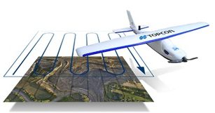
Topcon Releases Two UASs for Aerial Mapping
Topcon Positioning Group released two unmanned aircraft systems (UASs) for aerial mapping applications: the Sirius Pro and Sirius Basic fixed-wing aircraft systems.
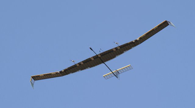
Pseudo-Satellite UAS Completes Test Under Harsh Conditions
Airbus Defence and Space announced the Zephyr 7 High Altitude Pseudo-Satellite, a type of unmanned aircraft, recently completed its most demanding mission to date.
