With assistance from Helix SRL, Supergeo’s partner in Italy, the Romanian company Black Light SRL has recently selected the well-known mobile GIS software SuperSurv as its mobile geospatial solution. Established in 1992, Black Light SRL is a surveying company with...
New Release of SuperGIS Server 3.2
Supergeo is proud to announce that the latest version of SuperGIS Server 3.2 is now available on our official website. This release includes some new features as well as improvements that make SuperGIS Server even better. For example, users can now publish pre-cached...
Phase One Industrial Announces 100 Megapixel Medium Format Metric Cameras for Aerial Data Acquisition
COPENHAGEN, January 3, 2016 ― Phase One Industrial, a leading developer of aerial medium format camera equipment, today announced 100 MP CMOS-based medium format metric cameras available for aerial mapping and other demanding applications. The development of the...
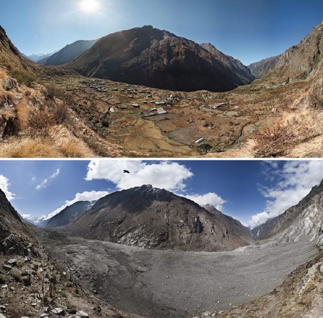
Satellite Imagery Catalogs Nepal Earthquake Landslides
Scientists with the Global Land Ice Measurements from Space (GLIMS) network, an international consortium of glaciologists, used satellite imagery to search for landslides after the April 25, 2015, earthquake that claimed more than 9,000 lives in four countries, primarily Nepal.
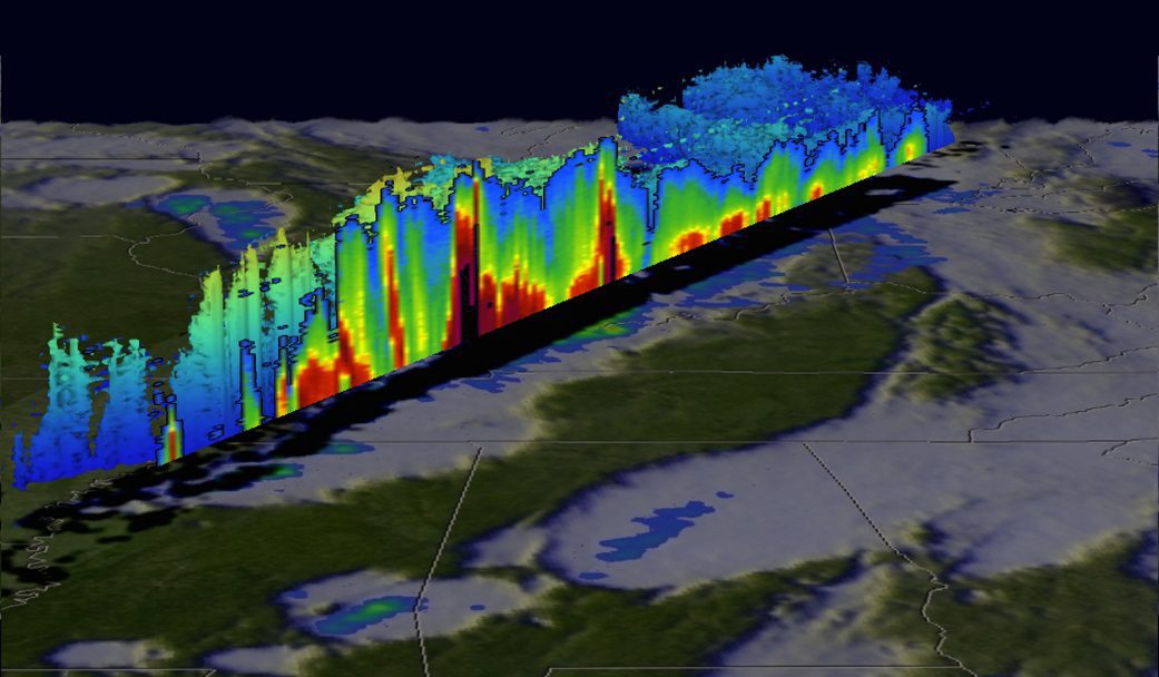
NASA Satellite Tracks Deadly U.S. Weather
The Global Precipitation Measurement (GPM) satellite, an international mission between NASA and the Japan Aerospace Exploration Agency, analyzed extreme weather that affected the United States between Dec. 23-27, 2015.
GeoCue Announces Release of LP360 2015.1
Huntsville, AL – GeoCue Group is pleased to announce the latest release of LP360. Available both as an add-in to ArcGIS® and as a standalone 64 bit application, LP360 is the world’s most powerful and popular LIDAR extension for the ESRI environment. This release...
NASA Looks at Deadly Weather Over the US
NASA's Global Precipitation Measurement or GPM mission core satellite analyzed extreme weather that affected the U.S. over the course of five days. Heavy rainfall, flooding and tornado outbreaks affected areas of the United States from the Southwest through the...
New Esri Book Teaches the Principles of Good Map Design
Redlands, Californi—Mapmakers should always strive to create maps that look great and get their message across clearly and succinctly. According to Esri president Jack Dangermond, more emphasis today needs to be placed on map design, especially on the web. "We need...
Badger State Maps Put TIGER in the Tank
The USGS US Topo map program has entered its third, three-year cycle of revising and updating the digital US Topo maps. To start this new cycle, the USGS National Geospatial Program is excited to announce the inclusion of U.S. Census Bureau’s Topologically...
10 Productive Years in Orbit for GIOVE-A, Galileo's Small Satellite Pathfinder
British small satellite manufacturer Surrey Satellite Technology Ltd (SSTL) is today marking the 10th year of in-orbit operations from its GIOVE-A satellite, the pathfinder mission for Europe’s Galileo satellite navigation programme. Since retirement from its...
