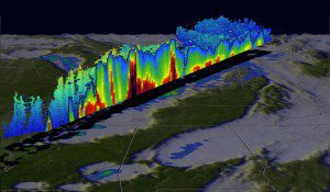
GPM data were used to create this color-enhanced 3-D slice through a line of storms on Dec. 23, 2015, that spawned tornadoes in Mississippi. (Credit: NASA/JAXA/SSAI, Hal Pierce)
The Global Precipitation Measurement (GPM) satellite, an international mission between NASA and the Japan Aerospace Exploration Agency to provide observations of rain and snow worldwide every three hours, analyzed extreme weather that affected the United States between Dec. 23-27, 2015. Heavy rainfall, flooding and tornado outbreaks affected areas of the United States from the Southwest through the Midwest.
The GPM satellite passed above a line of tornadic thunderstorms moving through the Midwest on Dec. 23, 2015. GPM’s Microwave Imager and Dual-Frequency Precipitation Radar instruments recorded the violent weather occurring near the center of the satellite’s swath. The supercell thunderstorm that moved from northern Mississippi into Tennessee generated two tornadoes. Fourteen deaths were attributed to tornadoes that hit Benton, Miss., on Dec. 23, 2015.

