Des Plaines, IL, February 9, 2016 — URISA is pleased to announce the 2016 members of its Vanguard Cabinet. The Vanguard Cabinet (VC) is a URISA initiative (which debuted in 2011) to engage young GIS practitioners, increase their numbers in the organization, and...
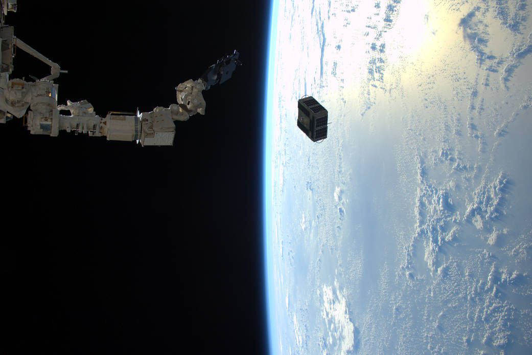
Space Station Deploys Student-Built Satellites
On Feb. 2, 2016, a robotic arm aboard the International Space Station deployed a pair of satellites built by students at Texas A&M University and the University of Texas.
Antarctica Losing Ice ˜Safety Band'
According to a report recently published in Nature Climate Change, satellite data is helping to reveal that there's a critical point where Antarctica's huge ice shelves act as a safety band, holding back the ice that flows to the sea.
ExpoDronica 2016 Brings for the First Time in the World Land, Sea and Air Drones
ExpoDronica 2016 Brings for the First Time in the World Land, Sea and Air Drones - The drone industry has taken off in 2015 and it expects to have an exponential growth throughout 2016, which will allow to develop new applications and a greater choice of solutions. -...
Pix4D and Parrot Release Precision Agriculture Solutions
Date: February 8, 2016 — Today Pix4D launches Pix4Dmapper Ag: a photogrammetric software that converts multispectral images into agriculture-specific maps for better crop management and analysis. The software is being released in conjunction with Sequoia: a...
Caliper Corporation Mapping Software Becomes an Associate Member of the Open Geospatial Consortium (OGC)
NEWTON, MA (USA) — Caliper Corporation, the leader in the development of cost-effective professional map software, has announced that is has become an associate member of the Open Geospatial Consortium. As an Associate Member, Caliper will participate in OGC's...
Proba-V Eyes Bolivia's Vanishing Lake
8 February 2016 — Monitoring Earth’s surface every day, ESA’s Proba-V minisatellite has had a ringside seat as the second largest lake in Bolivia gradually dried up. Lake Poopó has now been declared fully evaporated. The three 100-m resolution Proba-V images...
OGC Invites Input to Guide Point Cloud Standards Work
8 February 2016 — The Open Geospatial Consortium (OGC)  Point Cloud Domain Working Group (Point Cloud DWG) formed late last year to assess the current state of standards and best practices in the management of point cloud data and to guide OGC activities in...
Red Hen Systems at HAI Heli-Expo 2016 (Feb29-Mar3) Booth#12634
The HAI Heli-Expo 2016 is coming up sooner than you expect: Feb.29 - Mar.3 in Louisville, KY. Red Hen Systems will be there with our latest innovations for the aviation industry, built upon what we are known for-aerial video mapping with data multiplexing tool...
Korean Geotechnology Company Selects SuperGIS Desktop to Process Spatial Data
Supergeo Technologies Inc., the total GIS software and solution provider announces that Nexgeo has selected SuperGIS Desktop for processing and visualizing geospatial data. Headquartered in Seoul, Nexgeo is a Korean consulting firm and construction contractor involved...
