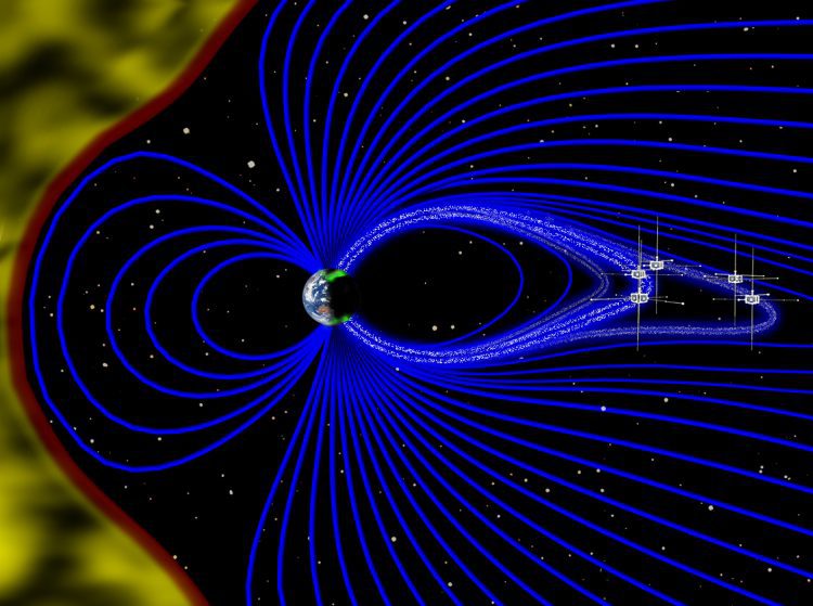
In 2013, the European Space Agency (ESA) launched a trio of Swarm satellites to monitor Earth's magnetic field. According to a research paper published in Science Advances on Sept. 30, 2016, the satellites were able to measure a faint magnetic field created by oceans that led to discoveries about Earth's electrical nature.
Scientific Ballooners Wrap Up Fourth and Final Campaign
Scientists of the Balloon Array for Radiation-belt Relativistic Electron Losses (BARREL) team sent their last balloon into the stratosphere over Sweden on Aug. 30, 2016, capping off four years of launches to study how electrons precipitate into Earth's atmosphere.
Fire-Detection Satellite BIROS Releases BEESAT-4 Picosatellite
On Sept. 9, 2016, the Bi-Spectral Infrared Optical System (BIROS) fire-detection satellite, developed and built by the German Aerospace Center (DLR), released the Berlin Educational and Experimental Picosatellite (BEESAT-4) into space 515 kilometers above the Norwegian Svalbard archipelago.
Satellites Record Auroras’ Rhythm
Using data from NASA's Time History of Events and Macroscale Interactions during Substorms (THEMIS) satellites, scientists have observed Earth's vibrating magnetic field in relation to the northern lights in the night sky over Canada.
Sentinel Satellite Hit by Space Particle
ESA engineers discovered that a solar panel on the Copernicus Sentinel-1A remote-sensing satellite was hit by a millimeter-sized particle on Aug. 23, 2016.
University of Nairobi Team Selected for KiboCUBE Project
The United Nations Office for Outer Space Affairs (UNOOSA) and the Japan Aerospace Exploration Agency (JAXA) selected a team from the University of Nairobi to be the first to benefit from the UNOOSA-JAXA KiboCUBE program.
Esri Maps NOAA's National Water Model
Smart-mapping leader Esri today released a beautiful, robust new collection of Web maps that forecast NOAA stream-flow data throughout the continental U.S.
Firecast Brings Satellite Data to Fire Managers in Remote Areas
Firecast monitors and delivers alerts for active fires, fire risk, and deforestation in the tropics. The project's web site and mobile application bring NASA satellite data to fire managers in areas that have traditionally relied on ground-based monitoring.
Peeking Under Greenland's Ice Sheet
Greenland's thick ice sheet insulates the bedrock below from the cold temperatures at the surface, so the bottom of the ice often is tens of degrees warmer than at the top.
Study Maps Hidden Water Pollution in U.S. Coastal Areas
Coastal waters and nearshore groundwater supplies along more than a fifth of coastlines in the contiguous United States are vulnerable to contamination from previously hidden underground transfers of water between the oceans and land.