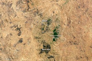
Firecast's new mobile application is being tested in Madagascar's Ambohitantely, a forested reserve that can be seen in this image acquired by the Operational Land Imager on the Landsat 8 satellite. (Credit: NASA Earth Observatory images by Jesse Allen, using Landsat data from the U.S. Geological Survey.)
Karyn Tabor wants to change the way people in remote areas manage wildfires. In Madagascar, for example, the current approach involves patrolling protected areas on foot to locate and extinguish fires before they grow larger. In June 2016, Tabor and colleagues introduced technology that could make fire detection easier.
The project is called Firecast”a system to monitor and deliver alerts for active fires, fire risk, and deforestation in the tropics. The project's web site and mobile application bring NASA satellite data to fire managers in areas that have traditionally relied on ground-based monitoring. Users can view maps of active fires, download daily fire risk forecasts, read reports of local fire activity, and see current activity in context with historical data.
Our niche is packaging and delivering NASA data to make it accessible to people who need the information for day-to-day conservation decisions, said Tabor, a scientist at Conservation International and principal investigator of the project, which is partly funded by NASA's applied sciences program.

