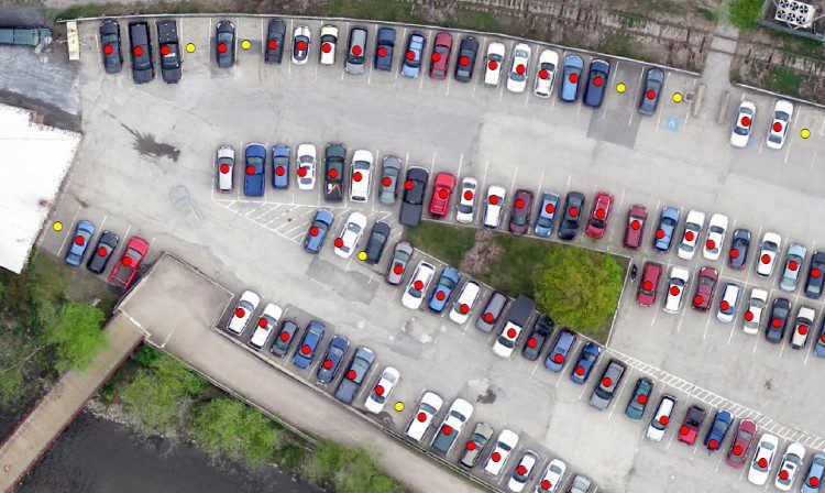
Remotely sensed data provide a snapshot in time, and thus seem perfect for a task such as parking-capacity inventory. Until recently, however, remote-sensing systems suffered from shortcomings that made them ill-suited to the task: satellite imagery lacked sufficient spatial resolution, and aerial imagery was never cost effective for small areas.
Data Cube Approach Introduces Architectures for EO Data
There are many barriers to accessing and applying satellite data, such as the cost and complexity of transmission, handling and storage as well as the need to calibrate and process large volumes of imagery from multiple satellites.
Story Map Navigates Cause and Effects of Climate Change
With the Atlas for a Changing Planet Story Map, scientists, policy makers, planners and activists can examine detailed spatial information critical for adapting to a warmer future.
Australian Scientists Create Wind-Dispersion Models to Assess Threats
A collaboration among Australia's national science agency (CSIRO), Bureau of Meteorology and Intersect created TAPPAS (Tool for Assessing Pest and Pathogen Aerial Spread), an online software tool for modeling the wind dispersal of living organisms.
USGS Publishes Remote-Sensing Handbook
The newly published, three-volume Remote Sensing Handbook includes remote-sensing topics written by more than 300 leading global experts.
SOHO Celebrates 20 Years in Space
Originally launched in 1995 by the European Space Agency (ESA) and NASA to study the sun and its influence out to the edges of the solar system, the Solar and Heliospheric Observatory (SOHO) revolutionized heliophysics, providing the basis for nearly 5,000 scientific papers.
ESA Seeks Proposals for Ninth Earth Explorer
The European Space Agency (ESA) is calling for Earth-observation scientists to submit proposals for the ninth Earth Explorer satellite mission.
Minuscule, Flexible Lenses Magnify Large Fields of View
Drawing inspiration from an insect’s multi-faceted eye, University of Wisconsin-Madison engineers created miniature lenses with vast range of vision.
Data Fusion Predicts Habitat Quality
Merrick & Company was recently honored by the American Council of Engineering Companies of Colorado (ACEC Colorado) at its annual Engineering Excellence Awards competition, which recognizes engineering projects that demonstrate a high degree of ingenuity and include significant technical, economic and/or social advancements.
New Satellite to Monitor Plant Health
The European Space Agency (ESA) plans to track the health of the world's vegetation by detecting and measuring the faint glow that plants give off as they convert sunlight and the atmosphere's carbon dioxide into energy.