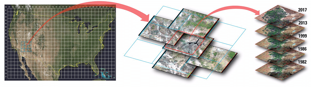
Improvements to the quality and usability of Landsat satellite data have been made with the release of a new USGS product called Landsat Analysis Ready Data (ARD), which will help reduce the time needed to process and analyze data and imagery, a significant advantage to scientists studying landscape changes, including changes from wildfires, hurricanes, vegetation cover, drought and other events.
Apollo 4 Test Flight Celebrates 50th Anniversary
On Nov. 9, 1967, the uncrewed Apollo 4 test flight made a great ellipse around Earth as a test of the translunar motors and high-speed entry required of a crewed flight returning from the moon. A 70-millimeter camera was programmed to look out a window toward Earth and take a series of photographs from high apogee.
Get Ready for GIS Day!
What better way to celebrate GIS Day than to host or attend an open house or a workshop that demonstrates the power of mapping.
Southern Italy and Sicily from Space Station
A photo of Southern Italy and Sicily was captured by ESA astronaut Paolo Nespoli aboard the International Space Station. Nespoli currently is working and living aboard the International Space Station as part of the Italian Space Agency long-duration mission VITA....
Drone Mapping Creates Digital Record of Endangered Archaeological Sites
Drone mapping provides a fast, accurate and noninvasive way to document archeological sites, creating a historical record of a country's cultural heritage and giving archaeologists a rich set of data and models to be used for further research.
Australia's Great Sandy Desert from Space
Flying hundreds of miles above Earth, astronauts aboard the International Space Station photographed Lake Hazlett and Lake Willis in Western Australia’s Great Sandy Desert.
Impact of Northern California Fires Seen in New NASA Satellite Image
As firefighters continue to work toward full containment of the rash of wildfires burning in Northern California, a new image from the Advanced Spaceborne Thermal Emission and Reflection Radiometer (ASTER) instrument on NASA’s Terra satellite shows the growing fire scar on the landscape.
MDA Completes Acquisition of DigitalGlobe, Company Renamed Maxar Technologies
MacDonald, Dettwiler and Associates (MDA) completed its acquisition of DigitalGlobe. The newly combined company will offer a broader set of space-based solutions, increased scale and a more-diversified revenue base.
Hurricane Ophelia's Temperature
The European Space Agency (ESA) Copernicus Sentinel-3A satellite saw the temperature at the top of Hurricane Ophelia on Oct. 15, 2017, as the storm approached the British Isles.
Satellites See Silicon Valley’s Quick Drought Recovery
Underground water reserves in California's Silicon Valley rebounded quickly from the state's recent severe drought, demonstrating the success of aggressive conservation measures, according to a new space-based study by NASA and university scientists.