Is LiDAR Disruptive Technology?

By Patrick Cunningham, president, Blue Marble Geographics (www.bluemarblegeo.com), Hallowell, Maine. The use of light detection and ranging (LiDAR) data has taken center stage in geospatial technology during the last few years. LiDAR data collection hardware vendors...

How to Interpret a Satellite Image

Five basic strategies will help you discover a wealth of knowledge. By Holli Riebeek, NASA Earth Observatory (http://earthobservatory.nasa.gov), Greenbelt, Md. Satellite images are like maps—they’re full of useful and interesting information as long as you have a...

Approaching the Age of Personal Remote Sensing

With unmanned aircraft systems looming, personal remote sensing by large numbers of individuals and businesses will become routine. By Mike Tully, president and CEO, Aerial Services Inc. (www.aerialservicesinc.com), Cedar Falls, Iowa. For the geospatial and remote...

State of the Industry Report

Technology Heats Up  Tracking the Trends Shaping the Remote Sensing Industry Technology never stands still, as illustrated by the many advances that have burst onto the scene in the remote sensing industry during the last few years. From increasingly sophisticated...

Designing Effective QC for LiDAR Projects

Designing Effective QC for LiDAR Projects

Applying consistent quality control methods throughout a LiDAR project can save time, reduce costs and ensure a better project. By Sonja Ellefson, a LiDAR analyst at Quantum Spatial (www.quantumspatial.com), Sheboygan, Wis. As light detection and ranging (LiDAR)...

Industry Updates Nov/Dec

Industry Updates Nov/Dec

DigitalGlobe Launches Educational Foundation DigitalGlobe launched the DigitalGlobe Foundation, a nonprofit organization focused on fostering the growth of the next generation of geospatial technology professionals. “The foundation was established on the belief that...

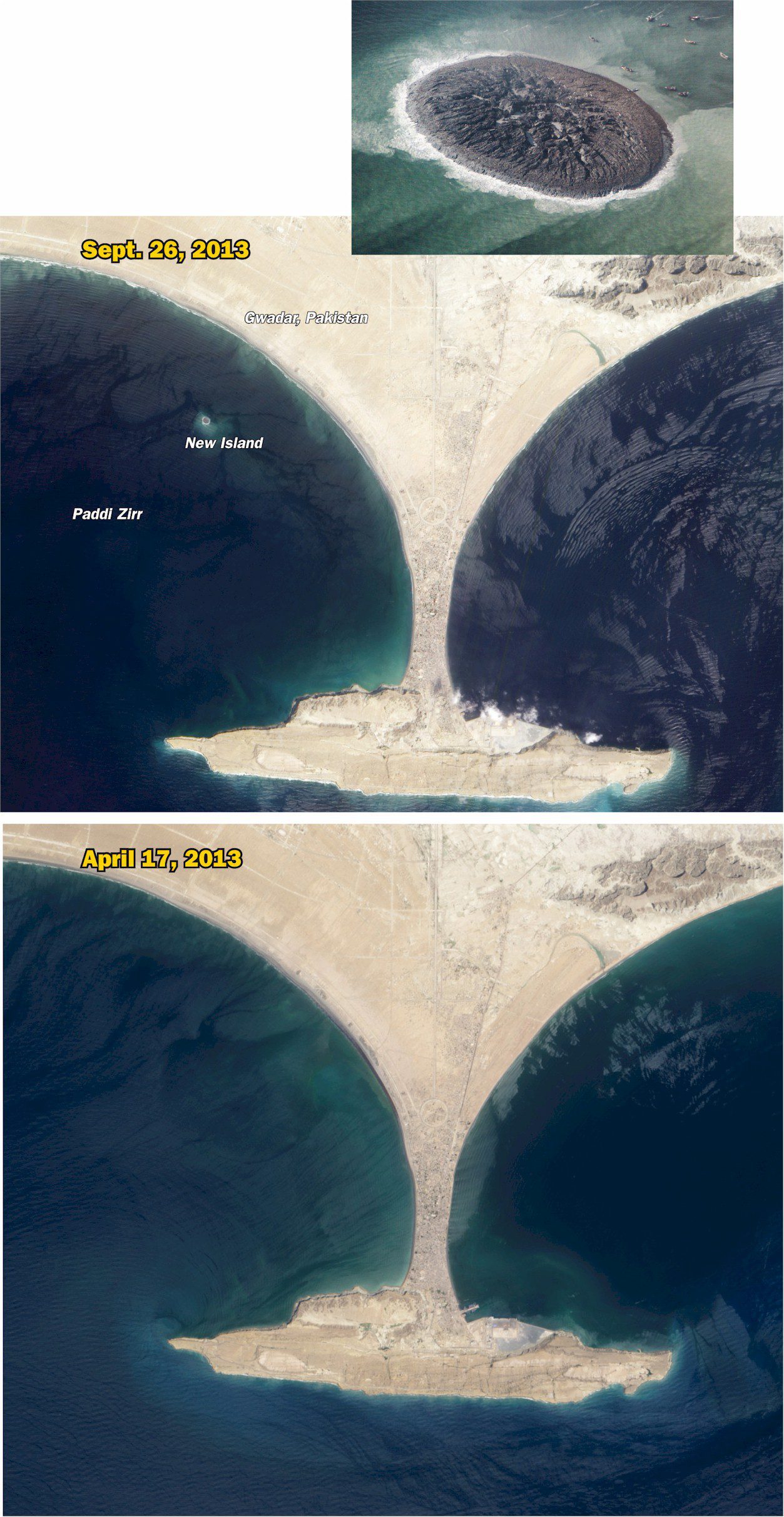
Earthquake  Births New Island off Pakistan

Earthquake Births New Island off Pakistan

On Sept. 24, 2013, a major earthquake rattled western Pakistan, killing at least 350 people and leaving more than 100,000 homeless. Amidst the destruction, a new island was created offshore in the Paddi Zirr (West Bay) near Gwadar, Pakistan. Likely a “mud...

Moving from Traditional GIS to Web GIS

By Jack Dangermond, founder and president of Esri (www.esri.com), Redlands, Calif. Today, our world is facing serious challenges on many fronts. It’s becoming clear we need to collectively work to create a better future. This means leveraging our best design talent,...

NEWEST V1 MEDIA PUBLICATION

April Issue 2024