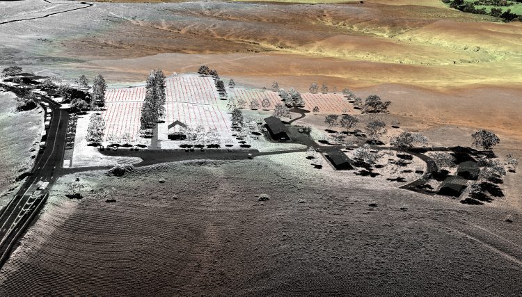
Ever wondered what Geoinformatics was? It’s a thing! Geoinformatics has other names – Geographic Information Science and GIS. No matter how you see it, GIS has become a growing field in the technology industry. So, it’s no surprise that many universities in the...
Key Technologies for Commercial Radio Frequency Signal Mapping with Small Satellites
Small satellite technology has ignited a revolution in Earth observation, enabling the launches of hundreds of imaging platforms into orbit in just the past few years.
Why Aerial Imagery Resolution Matters
A quantum leap in computing capacity has allowed us to model and analyze the real world – all from our desktop and mobile devices. In days past, maps were purely for visualization and direction. Today, they have graduated to full-blown analytics platforms empowering...
Attitude Control Technologies for Smaller Satellites Enable Complex Applications in Earth Observation, Space Astronomy and Science Research
In June 2016, GHGSat Inc. of Montreal launched a microsatellite called Claire on an ambitious demonstration mission to prove that greenhouse gas emissions from point sources on the ground could be monitored from space.
GIS to the Rescue: Unleashing the Power of Geospatial Technology to Plan for and Respond to Natural Disasters
The prevalence of such extreme weather events with the rise of the number and intensity of hurricanes that rolled through the region, bringing with them violent winds and rains, highlighted the importance of utilizing decision-support tools such as these that help communities better plan for disasters, expedite response operations and better position resources to minimize the impact of these inevitable and disastrous events.
Vertical Images: From Film Making to Inspection, and Why the Future of Drones Doesn't Lie in Flying
Successful drone entrepreneur Petr LnÄ›niÄka went from award-winning filmmaker to drone inspection leader in his native Czech Republic. Here he lays out 3 pieces of advice and explains why for him, the transition seemed logical, and why he believes the future of drone mapping services will place less and less emphasis on drones and more and more weight on mapping data.
How Drone Data Delivers Real Bottom Line Value for SMBs in Construction
Headquartered in Beaumont, California, Bogh Engineering is a 3rd generation family owned construction and engineering company with 65 employees. It focuses on construction of public schools, and is currently working on 14 job sites including building the 1.4 million...
How Do I Choose the Correct Image-Capture Settings for 3D Models?
What are the effects of the angle between images setting in circular missions when it comes to 3D reconstruction?
FAA's Part 107 Rules Ease Some of the Challenges Faced by Commercial UAS Operators
Users of UAS aerial images must be open to the idea that legitimate UAS operators interested in complying with the law might not be able to fly the mission as planned due to operational restrictions imposed by the FAA.
Topographic Lidar Data Employed to Map, Preserve U.S. History
In August 2015, the National Park Service (NPS) contracted Woolpert for the Little Bighorn National Monument Mapping Project to record the locations of thousands of headstone markers at the Custer National Cemetery as well as hundreds of battlefield markers at the Little Bighorn National Monument site, which covers approximately 5.5 square miles.