September 27, 2015
Although the wall-map pincushion is certainly still employed in some locales, the standard for imaging, mapping and emergency management is now digital; although still often behind available advancements.
July 16, 2015
By Chris Crosiar, Office of Basic and Applied Research, National Geospatial-Intelligence Agency (www.nga.mil), Springfield, Va. In my experience as a research and development scientist at the National Geospatial-Intelligence Agency, I recall a time when the mention of climate change was so taboo, analysts could only reference “an environmental anomaly.” Times have changed. During the last
July 16, 2015
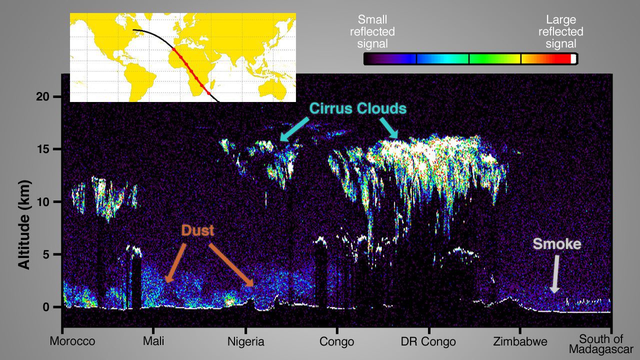
By Steve Cole, public affairs officer, Earth Science Division, NASA (www.nasa.gov), Washington, D.C. Four new NASA Earth-observing missions are collecting data from space—with a fifth newly in orbit—after the busiest year of NASA Earth science launches in more than a decade. On Feb. 27, 2014, NASA and the Japan Aerospace Exploration Agency (JAXA) launched the
July 16, 2015
When looking at all the coming changes to the geospatial technology tools and inputs that are emerging and immediately over the horizon, there’s a mixed feeling of excitement and trepidation. How will all of these new data-collection platforms, workflows and analytics impact the world of today’s practitioners as well as the vendor community?
June 11, 2015
By Michaela Mesquite, Analysis Technology Executive Team, National Geospatial-Intelligence Agency (www.nga.mil), Springfield, Va. When satellite imagery was novel and through the early years of geographic information system (GIS) computing, the predecessors to the National Geospatial-Intelligence Agency (NGA) stood nearly alone in the world of remote sensing and GIS technology. Now geospatial intelligence (GEOINT) is commercialized,
June 11, 2015
By Richard M. Medina, assistant professor, and George F. Hepner, professor, Department of Geography, University of Utah (www.geog.utah.edu), Salt Lake City. Today’s research environment is one in which basic research and understanding aren’t valued as much as engineering and tech-nology. Regarding geospatial intelligence (GEOINT), in many cases there’s more interest in capability-driven technologies rather than working
June 11, 2015
There’s no doubt that geospatial datasets are a prime example of “big data.” Clearly, when the goal of the geospatial industry is to record Earth’s changes through mapping and geospatial products and services, a planet-sized dataset can’t be small. The fact that the world is constantly changing and there’s continual innovation in the sensors and
April 5, 2015
By Patrick Meier, an internationally recognized thought leader on humanitarian technology and author of the new book Digital Humanitarians. He directs QCRI’s Social Innovation Program, where he partners with international organizations to develop next-generation humanitarian technologies. The view from the sky is hugely important for disaster response. Indeed, humanitarian organizations have been using satellite imagery
April 5, 2015
By George Demmy, chief technology officer, TerraGo Technologies (www.terragotech.com), Sterling, Va. Geospatial technology professionals built an industry on understanding the importance of data in a geographic context and facilitating decision-making by gathering and analyzing such data. The industry continues to grow because these professionals communicate results in ways that take some of the mystery out
April 5, 2015
With the purchase of Earth Imaging Journal this past quarter, our V1 Media team has been enjoying the spark of energy that comes from a new endeavor. We hope you’ve enjoyed a subtle fresh spin on the coverage and have had a chance to explore some of the new ways you can consume our content.