Des Plaines, Ill., June 11, 2014—URISA is pleased to announce that 45.0  AICP-CM (certification maintenance) credits (including 2.5 law credits) have been approved by the American Planning Association for GIS-Pro 2014: URISA’s 52nd Annual Conference taking place...
Elbit Systems Selected as Preferred Supplier for Swiss UAS Program
HAIFA, Israel, June 8, 2014—Elbit Systems Ltd. (NASDAQ and TASE: ESLT) ("Elbit Systems") announced today that it was selected by the Swiss Federal Department of Defence, Civil Protection and Sport ("DDPS"), as the preferred supplier for the UAS 15 new reconnaissance...
Hexagon Acquires North West Geomatics
STOCKHOLM, June 11, 2014—Hexagon AB, a leading global provider of design, measurement and visualisation technologies, has acquired the remaining 90 per cent of the shares in North West Geomatics Ltd., making the company a fully owned subsidiary of Hexagon. Hexagon...
Incumbent UAV Companies Likely to Face Increased Competitive Threats
AMSTERDAM, June 12, 2014—A new analysis of the leading companies in the unmanned aerial vehicle (UAV) and unmanned aerial systems (UAS) market, now available on ASDReports, provides a comprehensive analysis of this rapidly developing market and its leading...
Northrop Grumman to Supply Navigation System for South Korea’s GEO-KOMPSAT-2 Satellites
WOODLAND HILLS, Calif., June 10, 2014—Northrop Grumman Corporation (NYSE: NOC) has been awarded a contract from the Korea Aerospace Research Institute (KARI) to provide space inertial reference systems for the GEO-KOMPSAT-2 space satellite program. Under a...
Optech Celebrates 40 Years of Lidar Innovation
TORONTO, June 11, 2014—Optech is pleased to announce that it is celebrating 40 years of lidar technology innovation. To mark the occasion, Optech is paying tribute to the incredible partnership with our clients over the years, from the first commercial lidar systems...
Proteus Completes Satellite-Derived Forest Inventory Pilot in Abu Dhabi
ABU DHABI, UAE, and BRISTOL, UK, June 16, 2014—Proteus FZC, a provider of satellite-derived mapping and classification services, has completed a demonstration project using satellite imagery to inventory tree plantations in the Emirate of Abu Dhabi. The tree mapping...

Drone Spying on French Soccer Team?
After spotting a drone hovering over its practice on the first day of World Cup action, France's soccer team called for an investigation into the possibility that the team was spied on.
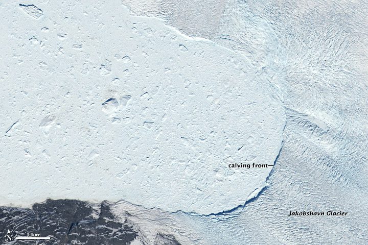
Satellite Records Giant Greenland Glacier Retreat
Among the world's most dynamic glaciers is Greenland's Jakobshavn Isbrae, which showed its active nature with a large calving event at the end of May 2014.
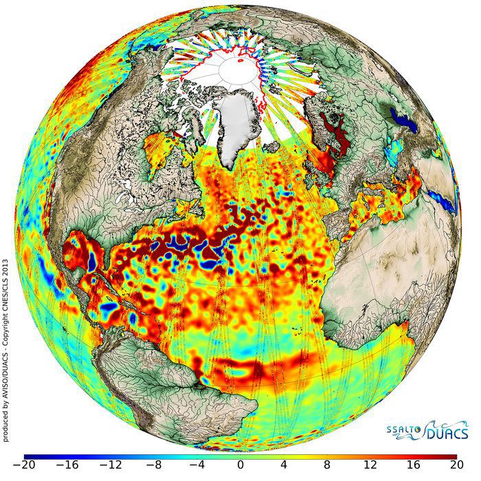
Cryosat Satellite Delivers Bonus Benefits
Going above and beyond its objective to measure changes in the thickness of polar sea ice, the European Space Agency's CryoSat satellite is a valuable data source for the oceanographic community.
