TORONTO, June 11, 2014—Optech is pleased to announce that it is celebrating 40 years of lidar technology innovation. To mark the occasion, Optech is paying tribute to the incredible partnership with our clients over the years, from the first commercial lidar systems...
Proteus Completes Satellite-Derived Forest Inventory Pilot in Abu Dhabi
ABU DHABI, UAE, and BRISTOL, UK, June 16, 2014—Proteus FZC, a provider of satellite-derived mapping and classification services, has completed a demonstration project using satellite imagery to inventory tree plantations in the Emirate of Abu Dhabi. The tree mapping...

Drone Spying on French Soccer Team?
After spotting a drone hovering over its practice on the first day of World Cup action, France's soccer team called for an investigation into the possibility that the team was spied on.
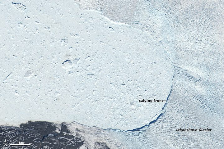
Satellite Records Giant Greenland Glacier Retreat
Among the world's most dynamic glaciers is Greenland's Jakobshavn Isbrae, which showed its active nature with a large calving event at the end of May 2014.
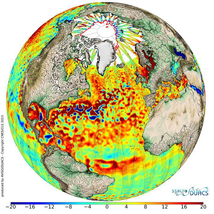
Cryosat Satellite Delivers Bonus Benefits
Going above and beyond its objective to measure changes in the thickness of polar sea ice, the European Space Agency's CryoSat satellite is a valuable data source for the oceanographic community.

Nevada Unmanned Aircraft Site Goes Live
The Federal Aviation Administration announced on June 9, 2014, that the state of Nevada's unmanned aircraft system (UAS) test site is ready to conduct research vital to integrating UASs into the nation's airspace.
Blue Marble Releases Global Mapper LiDAR Module with Powerful LiDAR Transformation Options
Hallowell, Maine, June 4, 2014—Blue Marble Geographics (bluemarblegeo.com) is pleased to announce the release of the LiDAR Module for Global Mapper version 15.2. This interim release features added support for the transformation (shift/rotate/scale) of LiDAR point...
Esri CityEngine Increases the Power of Virtual Design
Redlands, Calif., June 4, 2014—Esri has released CityEngine 2014, the latest version of its advanced 3D GIS urban design software. Architects, planners, and urban designers can make better decisions by using CityEngine to create more realistic city models and...
NATO HQ Launches Interactive Web Map Based on Esri Technology
Redlands, Calif., June 2, 2014—The North Atlantic Treaty Organization (NATO) has just released “NATO on Duty,†an interactive, multimedia web map based on Esri’s geographic information system (GIS) software. “The purpose of the map is to illustrate to the...
OGC Extensions to Web Coverage Service Standard Improve Access to Earth Data
May 29, 2014—The Open Geospatial Consortium (OGC®) Membership has approved six OGC Web Coverage Service (WCS) Interface Standard extensions as official OGC standards. These WCS extensions significantly expand the ability of researchers, environmental managers,...
