Graz, Austria, July 31, 2014—GEOCART GmbH has contracted with Microsoft’s UltraCam business unit and subsidiary to purchase an UltraCam Falcon, one of the well-known third-generation UltraCam digital aerial camera systems being adopted by many companies worldwide....
OSIsoft and Esri Partner to Deliver Unified Solution for U.S. Federal Government Organizations
SAN LEANDRO, Calif., July 29, 2014—OSIsoft and Esri today announced an agreement that will allow U.S. federal government customers to purchase the PI System and ArcGIS products via a single GSA IT 70 Schedule contract transaction. Orders should be placed...
SSL Selected for Study on Accommodating a NASA-Hosted Payload
PALO ALTO, Calif., July 28, 2014—Space Systems/Loral (SSL), a leading provider of commercial satellites, today announced that it was selected by the Department of the Air Force Headquarters Space and Missile Systems Center as one of three companies to study ways to...
SSTL Marks Completion of TechDemoSat-1 LEOP Phase with a Selfie
GUILDFORD, United Kingdom, July 24, 2014—Surrey Satellite Technology Ltd (SSTL) released an image taken by an inspection camera on board TechDemoSat-1 to mark the completion of the Launch and Early Operations Phase (LEOP) for the satellite, which was launched on 8th...
Surrey Satellite US Announces Second Orbital Test Bed Ride-Share Mission
ENGLEWOOD, COLO., July 30, 2014—Surrey Satellite Technology US LLC (SST-US) today announced plans for a second Orbital Test Bed (OTB-2) ride-share mission dedicated to carrying demonstration payloads, subsystems, and equipment into low-Earth orbit aboard a...
Unmanned K-MAX Cargo Helicopter Team Returns from Deployment with U.S. Marine Corps in Afghanistan
OWEGO, N.Y., July 24, 2014—After lifting more than 4.5 million pounds of cargo and conducting thousands of delivery missions for the U.S. Marine Corps, the Lockheed Martin [NYSE:LMT] and Kaman Aerospace Corporation [NYSE: KAMN] K-MAX cargo unmanned aircraft system...
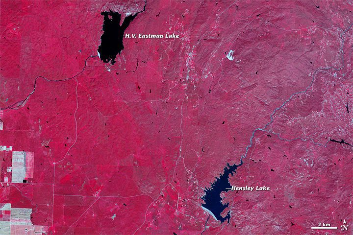
California Drought Deepens by the Week
On July 31, 2014, 82 percent of California was in an extreme drought and 58 percent was in exceptional drought”up from 79 and 36 percent just two weeks earlier. Infrared satellite images are striking.
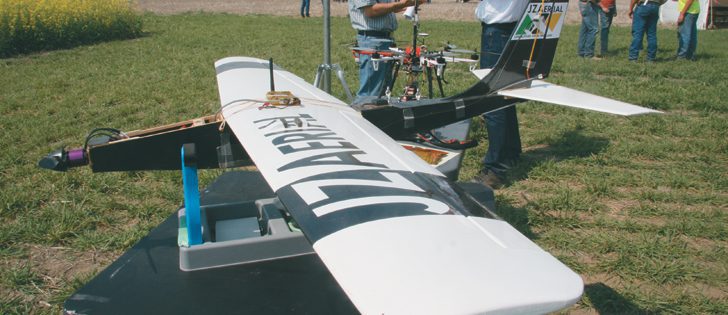
Weeds Can't Duck Drones
Researcher Chris Neeser, an Alberta Agriculture weed pest specialist, is experimenting with using unmanned aerial systems, or drones, to identify weed problems in crops.
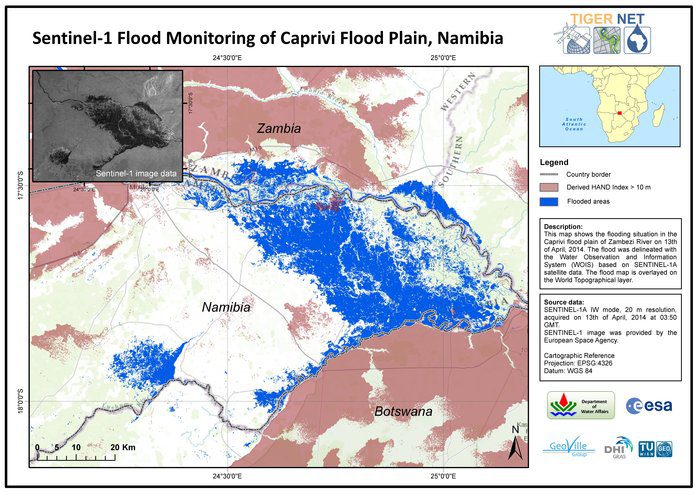
ESA Moves Forward with Second Sentinel Satellite
The European Space Agency's second Sentinel-1 satellite is set to join its identical twin in orbit in early 2016, optimizing the mission's ability to manage the environment and improve everyday lives.
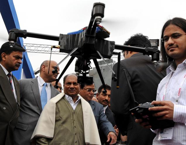
Indian Drone Used to Monitor Landslide
India's National Disaster Response Force is using Netra, an unmanned aerial system, to assess a landslide site in Ambegaon taluka.
