EDRS-A, the first relay satellite of the SpaceDataHighway, was successfully launched into geostationary orbit on 30Â January 2016. After a test period, it will become operational for its first end-user customer by mid-2016. The SpaceDataHighway system will provide...

Crowdsourced Project to Monitor California Coast
DroneDeploy and The Nature Conservancy partnered to create California's Phones and Drones project, which allows citizens to help create a crowdsourced map of the California coast.
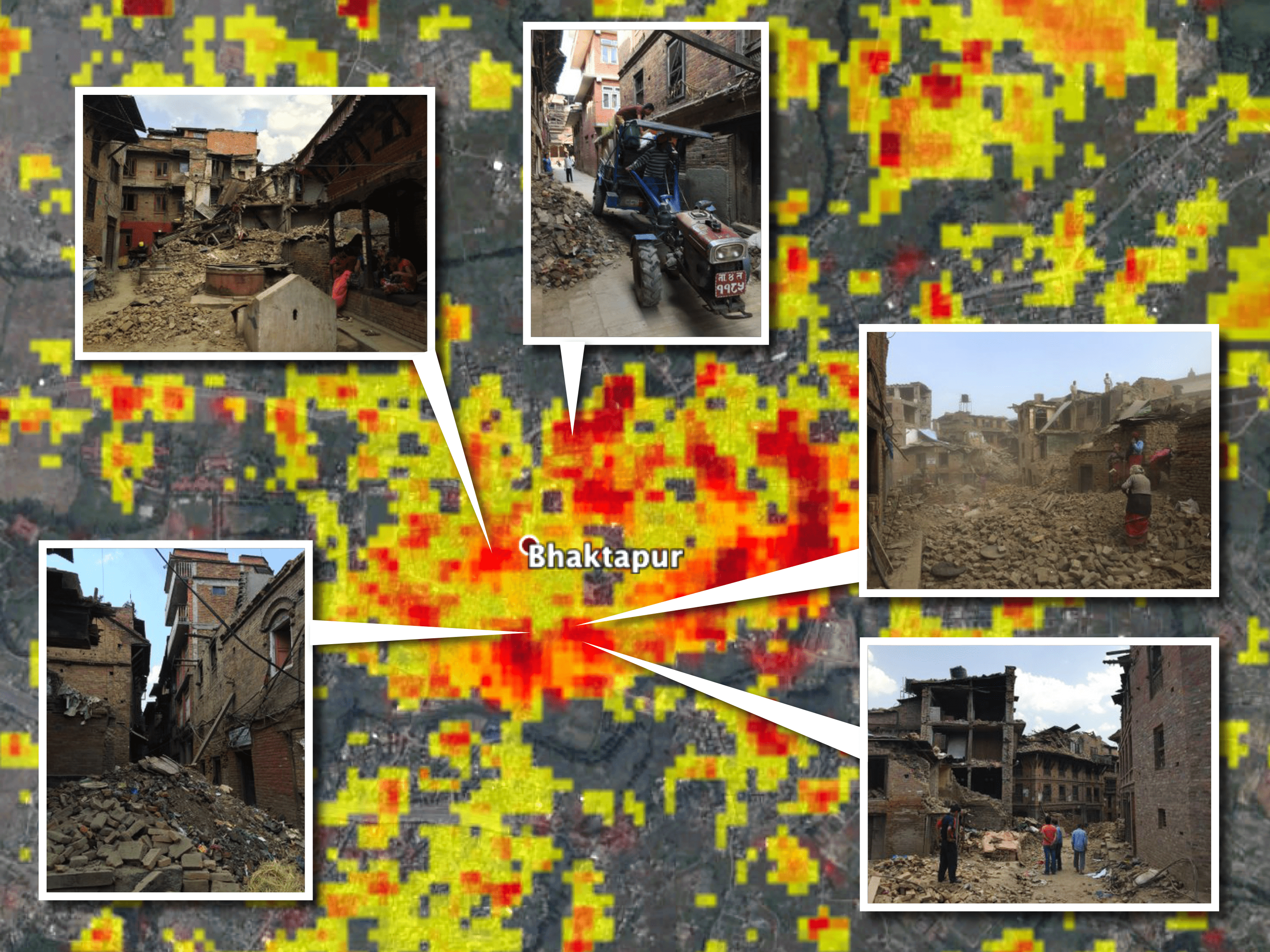
NASA Scientists Develop ˜Damage Maps' from Satellite Images
Researchers led by Sang-Ho Yun at NASA's Jet Propulsion Laboratory developed a way to create damage maps from satellite imagery”even if images are taken at night or when skies are cloudy.
Mayor Garcetti And Esri Launch Innovative Platform That Puts Open Data To Work
GeoHub makes the City’s extensive collection of map-based data available for real-time analysis and use by decision-makers, first responders, and the public. Mayor Eric Garcetti and Esri President Jack Dangermond today unveiled the City of Los Angeles’...
Aerial MOB, LLC and Quantum Spatial Inc. Announce Strategic Alliance
San Diego, California, February 1, 2016 — ​Aerial MOB, LLC, a leader in UAS (drone) aerial technology applications, has reached a strategic partnership agreement with Quantum Spatial Inc. (QSI), a leading supplier of geospatial data and solutions. Aerial MOB...
Sickweather Opens Disease Tracking Technology to Developers
BALTIMORE, MD – January 29th, 2016 — Sickweather, developer of the world’s first real-time map of illness, has recently opened their cognitive API (application programming interface) for disease surveillance to outside developers. The Techstars community gets...
Panzura Launches “Google Maps” Based Console That Finally Lets Companies Fully Use Cloud Storage as Primary Storage
CAMPBELL, CA, Jan 29, 2016 — Panzura, leading the charge in removing the barrier to the cloud, today announced immediate availability of its CloudFS Console, a Google Maps-based monitoring, alerting and reporting interface for the entire Panzura Global File...
Headwall Announces Five New Reseller Organizations
Fitchburg, MA, January 29, 2016 — Headwall Photonics is responding to significant growth in its core market segments by naming five new sales representative organizations. These companies are leaders in providing advanced instrumentation solutions to the remote...
OGC Seeks Public Comment on Discussion Paper Describing JSON Implementation of the OGC and ISO Observations & Measurements Standard
29 January 2016 — The Open Geospatial Consortium (OGC) requests public comment on the OGC OGC Observations and Measurements – JSON Implementation Discussion Paper. IT progress from 2000-2010 provided the Web services foundation that supports OGC Web Services,...
RIEGL is Attending the 2016 LFM User Meeting! Join Us for A Day in the Field Demonstrations!
RIEGL will be attending the 2016 LFM User Meeting and participating in A Day in the Field! The 2016 LFM User Meeting is your opportunity to experience the latest and greatest LFM solutions, learn about new technologies that will be coming soon and most importantly,...
