DUBUQUE, IOWA — June 20, 2016 — Cartegraph is now an Esri® Platinum Tier Business Partner. This move enhances an already-strong partnership between two enterprise business systems that enable local government agencies to gain greater insight, solve problems,...
Cardno UAS Fleet Achieves New Levels of Industry-leading Performance & Accuracy
Lone Tree, CO – July 20, 2016 - Cardno, Inc. announced that the newest platform in its industry-leading unmanned aircraft system (UAS) fleet is the Pulse Aerospace Vapor 55 on which the Riegl VUX-1 LiDAR sensor will be mounted. It will be deployed primarily for...
McKim & Creed Growing in Charlotte
Charlotte—The national engineering, surveying and planning firm of McKim & Creed, Inc. has added six engineering and geomatics professionals to its Charlotte office. This brings the company’s local staff size to more than 50, offering a wide array of...
ContextCapture Improves Quality of Reality Modeling Within Geospatial Workflows
Bentley Systems announces general access to the latest release of ContextCapture and ContextCapture Center. This release enhances the accessibility, scale, and quality of reality models that can be produced for use in BIM and geospatial workflows. Key capabilities...
GEO Jobe GIS Recruits New Chief Marketing Officer (CMO)
NASHVILLE, Tenn. - GEO Jobe, a leading GIS software and geospatial solutions provider, welcomes their new Chief Marketing Officer, Glenn Letham to their Geospatial Division. Glenn will be working closely with our teams in Nashville, TN, Biloxi, MS, and Redlands, CA....
CLEERIO, a Geolocation Asset Management Solution for Cities and Municipalities, Expands Operations in the United States
Las Vegas, Nevada - CLEERIO® Inc., provider of an innovative geolocation asset management platform solution with corporate headquarters in Las Vegas, today announced that it is expanding its operations in the United States. With 1,400 customers worldwide, CLEERIO...
20 New Countries to Invest in Space Programs by 2025
Paris, Washington D.C., Montreal, Yokohama, July 19, 2016Â - According to Euroconsult's latest report, Trends & Prospects for Emerging Space Programs, 24 countries are identified as emerging space programs (ESPs) in 2015 having launched a total of 69 satellites in...
LandWorks Tightens Integration with Esri in Land Management Software Upgrades
HOUSTON, TEXAS, July 19, 2016 – LandWorks Inc., a developer of innovative land management solutions, today introduced Release 5.50 of its three primary software suites – LandWorks Property Management, LandWorks GIS, and WebMaps Enterprise GIS. All three have been...
SSTL Expands LEO Platform Capability with VESTA Nanosatellite
Surrey Satellite Technology Ltd (SSTL) has signed a contract with Honeywell to supply the VESTA satellite platform, a technology demonstration mission that will test a new two-way VHF Data Exchange System (VDES) payload for the exactEarth advanced maritime satellite...
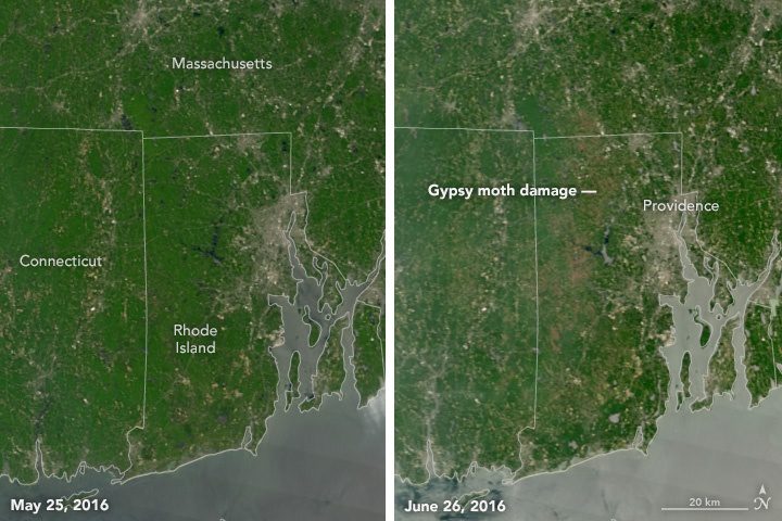
Moth Damage Seen from Space
Although the headline conjures images of Mothra from the old Godzilla movies, the destructive insects in this care are the European gypsy moth caterpillar, which is experiencing a population boom and chewing through large swaths of hardwood forest in New England and the Mid-Atlantic.
