Arcus Global, developer of cloud-based software solutions for the UK public sector, has joined the Cadcorp Business Partner Network. Arcus applications are built to support digital service transformation in local authorities. Their applications often incorporate...
GDU Revolutionizes Drone Industry with Universal Flying Platform Gimbal Line
LAS VEGAS — GDU, the leading consumer drone manufacturer focusing on power and portability, today officially launched a new line of interchangeable camera gimbals for different needs and specific uses. Not only was GDU (then named ProDrone) the first manufacturer to...
Quanergy and Civil Maps Announce Integrated Solution to Power Advanced Real-Time Localization and Mapping for Self-Driving Vehicles
SUNNYVALE, Calif. — Quanergy Systems, Inc., the leading provider of LiDAR sensors and smart sensing solutions, today announced a new integrated solution with Civil Maps, an autonomous vehicle software company providing cognition for cars. Quanergy’s innovative...
MapQuest Relaunches Popular Multi-Stop Route Planner
DENVER —  MapQuest ( mapquest), a pioneer in the digital mapping category, recently announced the relaunch of its popular Route Planner, a patented technology that simplifies the process of creating, optimizing and manipulating complex routes with multiple stops....
Almalence Video SuperSensor Software Now Improves Video Image Quality Powered by Cadence Tensilica Vision DSP
SAN JOSE, Calif. —  Cadence Design Systems, Inc. (NASDAQ: CDNS) today announced that Almalence, a leader in computational imaging, has collaborated with Cadence to port their Video SuperSensor video image quality improvement software to the Cadence® Tensilica®...
GDU Launches the Open Platform Partner Program for New Drone Development
LAS VEGAS — GDU, the leading consumer drone manufacturer focusing on power and portability, today officially announced that the company launched the Open Platform Partner Program to encourage participation with partners for new and exciting modular accessories for...
2017-2018 URISA Vanguard Cabinet Members Announced
Des Plaines, IL - URISA is pleased to announce the newest members of its Vanguard Cabinet. The Vanguard Cabinet (VC) is a URISA initiative (which debuted in 2011) to engage young GIS practitioners, increase their numbers in the organization, and better understand...
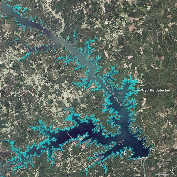
Scientists Use Satellites to Study Bird-Killing Bacteria
Around Lake Thurmond, a large reservoir that straddles Georgia and South Carolina, something's not right with the birds. The lake is full of vegetation”particularly an invasive aquatic plant known as Hydrilla verticillata”and the area is full of birds that are distressed or dying.
Avenza MAPublisher Now Features ArcGIS Online Integration within Adobe Illustrator
Toronto, ON - Avenza Systems Inc., producers of the Avenza Maps app for mobile devices and geospatial plug-ins for Adobe Creative Cloud, including Geographic Imager® for Adobe Photoshop®, is pleased to announce the highly anticipated integration of ArcGIS Online...
Woolpert Contracted to Collect Orthoimagery for Ohio
COLUMBUS, Ohio — Woolpert has been contracted to acquire high-resolution orthoimagery for the entire state of Ohio, which is roughly 41,276 square miles, by the Ohio Geographically Referenced Information Program (OGRIP). This project is the third iteration of the...
