Des Plaines, IL - URISA is pleased to announce the newest members of its Vanguard Cabinet. The Vanguard Cabinet (VC) is a URISA initiative (which debuted in 2011) to engage young GIS practitioners, increase their numbers in the organization, and better understand...
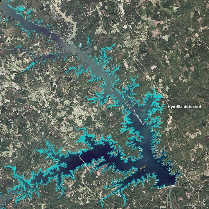
Scientists Use Satellites to Study Bird-Killing Bacteria
Around Lake Thurmond, a large reservoir that straddles Georgia and South Carolina, something's not right with the birds. The lake is full of vegetation”particularly an invasive aquatic plant known as Hydrilla verticillata”and the area is full of birds that are distressed or dying.
Avenza MAPublisher Now Features ArcGIS Online Integration within Adobe Illustrator
Toronto, ON - Avenza Systems Inc., producers of the Avenza Maps app for mobile devices and geospatial plug-ins for Adobe Creative Cloud, including Geographic Imager® for Adobe Photoshop®, is pleased to announce the highly anticipated integration of ArcGIS Online...
Woolpert Contracted to Collect Orthoimagery for Ohio
COLUMBUS, Ohio — Woolpert has been contracted to acquire high-resolution orthoimagery for the entire state of Ohio, which is roughly 41,276 square miles, by the Ohio Geographically Referenced Information Program (OGRIP). This project is the third iteration of the...
Maproom Plugs in CyberCity 3D Cities to 3ds Max
El Segundo, CA - Maproom, a powerful plug-in invented by Netherlands-based software developer Klaas Nienhuis, now enables users to create streamlined 3D city models quickly and easily in Autodesk’s 3ds Max®. Nienhuis developed Maproom to make it fast, easy, and...
FLIR Launches Five New Thermal Cameras at CES 2017: Third Generation FLIR ONEs, FLIR Duo Thermal/Visible Drone Cameras, and FLIR C3 Rugged Pro Camera
WILSONVILLE, OR - FLIR Systems, Inc. (NASDAQ: FLIR) announced today the launch of five new thermal imaging cameras at the 2017 Consumer Electronics Show (CES), including two new third generation FLIR ONE thermal camera attachments for smartphones, two new dual sensor...
ITRI Introduces Remotely-Operated Autonomous Drone (ROAD) at CES 2017, Booth #2015
LAS VEGAS — CES 2017 – Industrial Technology Research Institute (ITRI), Taiwan's largest and one of the world's leading high-tech applied research institutions, today announced it will introduce and demonstrate its ICT Solution for Drones at CES 2017. ITRI...
Qlik Delivers Advanced GeoAnalytic Offerings with Acquisition of Idevio
RADNOR, Pa. — Qlik®, a leader in visual analytics, today announced it has acquired Idevio, a provider of geographical-related software and services and a Sweden-based Qlik partner. This acquisition not only extends Qlik’s current mapping capabilities, but also...
TomTom Automotive Powers the Future of Driving
LAS VEGAS — TomTom ( TOM2) today announced that the majority of OEMs present in the Automotive Hall (LVCC North Hall) at CES are currently evaluating TomTom HD Maps to develop autonomous driving technologies. TomTom’s HD Map, including RoadDNA, is a...
GRASS GIS 7.2.0 Released
We are pleased to announce the stable release of GRASS GIS 7.2.0 What's new in a nutshell After almost two years of development the new stable major release GRASS GIS 7.2.0 is available. It provides more than 1950 stability fixes and manual improvements compared to...
