CENTENNIAL, Colo., Sept. 30, 2013—The Compass family of geospatial companies has established Compass4Colorado, a collaborative effort to make high-tech GIS and mapping capabilities available at no or low cost to organizations involved in the recovery activities...
East View Geospatial Named as Source for English-Japanese Bilingual Map Production
MINNEAPOLIS, Minn., Sept. 23, 2013—After successfully delivering a Japanese to English translation of topographic maps over the tsunami-affected areas in the Sendai region in 2011, East View Geospatial (EVG) has been granted the exclusive rights to produce and...
Esri Provides Software and Expertise as Part of the European Location Framework
Redlands, Calif., Sept. 30, 2013—Esri has joined the European Location Framework (ELF) project to assist in harmonizing and sharing geospatial data across Europe. As part of the project team, Esri has agreed to a grant offer with EuroGeographics to help its 59...
Merrick & Company Announces Business Partnership with Euclideon
GREENWOOD VILLAGE, Colo., Sept. 30, 2013—Merrick & Company’s (www.merrick.com)  Geospatial Solutions (GSS) group is pleased to announce that it has signed an agreement with Euclideon (www.euclideon.com) to distribute the Geoverse software product line....
RapidEye Completes North American Agricultural Imaging Campaign
Berlin, Germany, Sept. 30, 2013—RapidEye announced today that its North American agricultural imaging campaign has been completed successfully. The campaign, which ran monthly from May 15, 2013 through September 14, 2013, generated more than 16 million km² of...
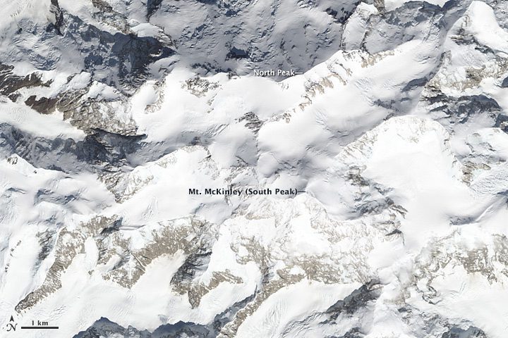
How Tall Is Mount Denali?
New U.S. Geological Survey 5-meter Interferometric Synthethic Aperture Radar data suggest North America's tallest peak may be 83 feet shorter than previously thought.

Three States Form Cooperative Drone Pact
Governors of Maryland, New Jersey and Virginia are supporting efforts by three universities in their respective states to partner on a Federal Aviation Administration drone test site.
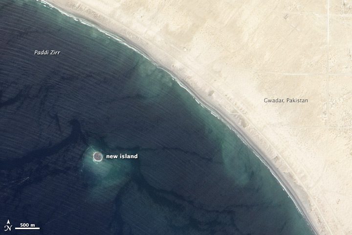
Deadly Earthquake Forms New Island off Pakistan
On Sept. 24, 2013, a 7.7-magnitude earthquake rattled western Pakistan, leaving at least 350 people dead and than 100,000 homeless. The quake also created a new island near Gwadar, Pakistan.

DOJ Spends Millions on Drones
A September 2013 Department of Justice report reveals the agency has spent $3.7 million on small drones since 2006, including $3 million for the Federal Bureau of Investigation.
Aurora’s Orion UAS Successfully Completes First Flight
MANASSAS, Va., Sept. 17, 2013—Aurora Flight Sciences announced today at the Air Force Association Air and Space Conference that the Orion Unmanned Aerial System (UAS) successfully completed its first flight on August 24, 2013. The flight was conducted on a western...
