In November 2013, a western Pacific Ocean seafloor volcano formed a new island 500 meters from existing Nishino-shima Island; four months later, they have combined to form one island.
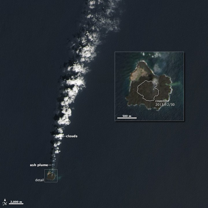
In November 2013, a western Pacific Ocean seafloor volcano formed a new island 500 meters from existing Nishino-shima Island; four months later, they have combined to form one island.
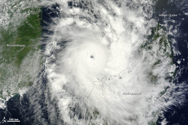
On March 30, 2014, the outlook appeared grim for northwestern Madagascar. Tropical cyclone Hellen spun offshore, rapidly gaining strength with a track destined to bring it ashore.

Researchers have tested a compact radar system integrated on a small unmanned aircraft system (SUAS) to look through the ice and map the topography underlying rapidly moving glaciers.
Worcester, Mass., March 27, 2014—Clark Labs is pleased to announce that Geocarto International Centre in Hong Kong, has recently published a new version of Remote Sensing with IDRISI: A Beginner's Guide, authored by Timothy Warner and David J. Campagna and updated...
PARIS, MONTREAL, WASHINGTON D.C., March 27, 2014—Data distributors and services providers have established themselves as a key component of the EO value-chain and an important partner of the EO satellite operators in order to disseminate data to the largest number...
Louisville, Ky., March 24, 2014—From the ASPRS conference in Louisville, Kentucky, Microsoft’s UltraCam business unit introduces an updated version of the UltraCam Osprey, a digital aerial system that combines a high performing photogrammetric nadir camera with...
Copenhagen, March 24, 2014—Phase One Industrial, a leading manufacturer and provider of medium format aerial digital photography equipment and software solutions, today announced the Phase One iXU 150 — the first CMOS-based medium format aerial camera. The Phase...
LOUISVILLE, Ky., March 28, 2014—Trimble (NASDAQ: TRMB) announced today the latest version of its eCognition® software for geospatial data analysis at the American Society for Photogrammetry and Remote Sensing (ASPRS) conference. Trimble eCognition software is a...
Houston and Louisville, Ky., March 24, 2014—Visual Intelligence today unveiled a new digital aerial sensor that redefines the capabilities and flexibility of medium-format geoimaging cameras at the ASPRS 2014 Annual Conference in Louisville. “Medium format cameras...
Des Plaines, Ill., March 26, 2014—Each year the four URISA chapters in California, along with the California Geographic Information Association, come together to present the California GIS Conference. This year, the conference will celebrate the milestone 20th...
