TORONTO, July 23, 2014—Optech is pleased to announce that NM Group has acquired their fourth airborne lidar system from Optech, a state-of-the-art Orion C300 that will greatly support the expansion of the company’s operations. Based in North America, Europe and...
OGC Announces New Geospatial User Feedback Standards Working Group
July 17, 2014—Members of the Open Geospatial Consortium (OGC®) have formed an OGC Geospatial User Feedback Standards Working Group (SWG). The purpose of this SWG will be to reach consensus on a standard way to encode users’ comments on the results those users...
Headwall Selects SBG Systems' Inertial Sensor for Full-Featured UAV-Based Remote Sensing Solution
Rueil-Malmaison, France, July 22, 2014—With the strong support of SBG Systems, Headwall offers a unique a fully integrated remote sensing solution, combining hyperspectral and LiDAR sensors on a small Unmanned Air Vehicle (UAV). Headwall has selected the Ekinox-N...
Woolpert to Provide Aerial Mapping for West Virginia
DAYTON, Ohio, July 21, 2014—Woolpert, a national geospatial, infrastructure management and design firm headquartered in Dayton, announced that it has been awarded a one-year contract with the West Virginia Department of Transportation, Division of Highways to...

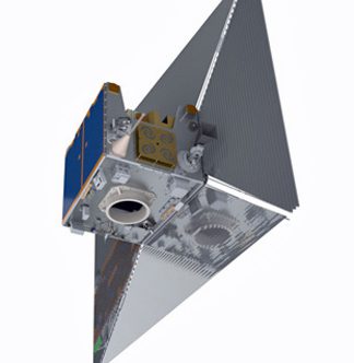
NASA Launches Long-Awaited Carbon Mission
The Orbiting Carbon Observatory-2 satellite aims to pinpoint atmospheric carbon dioxide, the leading human-produced greenhouse gas responsible for warming our world.
Satellite Sail Could Mitigate Orbital Debris Problem
At the end of its mission, the descent of Surrey Satellite Technology Ltd.’s TechDemoSat-1 satellite will be assisted by a specialized de-orbit sail just one-thousandth of an inch thick.

Skycatch Aims to Offer Drones for Hire
Skycatch, like Google's recently purchased satellite venture, is seeking ways to make high-resolution, easily accessible aerial imagery a part of how the everyday world works.

Citizen Scientists Take Control of Abandoned NASA Satellite
With NASA's blessing and following a successful crowd-funding campaign, a group of citizen scientists have taken control of an abandoned NASA satellite with plans to put it back to work.
Geographic Calculator 2014 SP1 Now Available with New Jobs to Streamline Workflow
Hallowell, Maine, July 22, 2014—Blue Marble Geographics (bluemarblegeo.com) is pleased to announce the release of the Geographic Calculator 2014 Service Pack 1 (SP1). This interim release features new job functions including the Area Calculation Tool and the Line...
Insitu Demonstrates Long Endurance Capabilities of the Integrator Unmanned Aircraft
BINGEN, Wash., July 22, 2014—Insitu announced today the successful 24-hour flight of its Integrator unmanned aircraft. The flight demonstrated Integrator's expanded endurance at an increased gross take-off weight with payload on board. The event is the first of...
