Herndon, Virginia (Feb. 29, 2016)—The United States Geospatial Intelligence Foundation (USGIF) CEO Keith J. Masback has been appointed Vice Chair of the National Geospatial Advisory Committee (NGAC). The NGAC provides recommendations to the Federal Geographic Data...
Louisiana DOTD Goes Mobile to Inspect Levees and More with TerraGo Edge
Washington, D.C. – TerraGo announced today the Louisiana Department of Transportation and Development (DOTD) has deployed TerraGo Edge for the inspection of flood protection infrastructure including levees, dams and reservoirs. The DOTD’s Public Works and Water...
State of Louisiana Saves Lives with Boundless by Thinking Open
Washington, DC and Baton Rouge, LA – As contribution to the effort to keep the most vulnerable citizens out of the path of dangerous storms and hurricanes, Boundless today announced its support of the Louisiana Department of Health and Hospitals (DHH) initiative...
GSDI 15 Conference Website Launched – Abstract submission open
On behalf of the Organising Committee, the Global Spatial Data Infrastructure Association (GSDI) is pleased to announce that the GSDI 15 World Conference website is now live! The conference website offers prospective attendees, exhibitors, and sponsors the opportunity...
East View Secures New Partnership Agreement with Valtus
MINNEAPOLIS - March 1, 2016 - East View Geospatial is excited to announce an agreement with Valtus Imagery Services, part of Hexagon, adding fresh, high resolution aerial imagery to its continually growing product portfolio. East View Geospatial will now be able to...
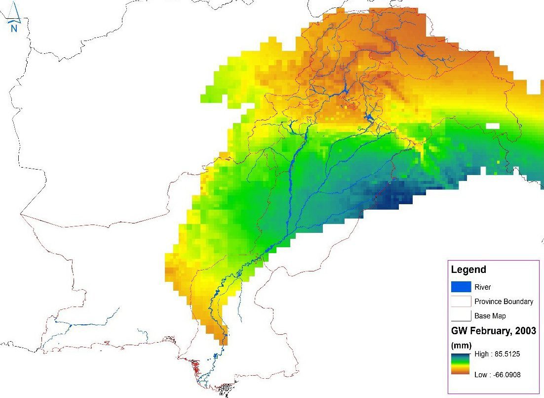
Satellites Help Monitor Pakistani Groundwater
After decades of unchecked pumping from underground water reservoirs, the Pakistan Council of Research in Water Resources in January 2016 began using satellite data from NASA's Gravity Recovery and Climate Experiment (GRACE) mission to create monthly updates on groundwater storage changes in the Indus River basin.
Penn State Offers Online Earth-Observation Education
The Department of Geography in the College of Earth and Mineral Sciences at The Pennsylvania State University continues to lead academically in geospatial sciences through its Remote Sensing and Earth Observation Program and its Online Geospatial Education Program Office.
Trimble’s Acutime 360 Multi-GNSS Timing Antenna Provides Smooth Path to BeiDou and Galileo
SUNNYVALE, Calif., — Trimble (NASDAQ: TRMB) introduced today its latest smart antenna with an integrated multi-GNSS receiver for high accuracy and precise timing applications—the Acutime™ 360. The smart antenna provides a pulse-per-second (PPS) output...
Interior Department Appoints New Members and Leadership to National Geospatial Advisory Committee
WASHINGTON — Secretary of the Interior Sally Jewell has appointed a new Chair and Vice Chair and 14 new and continuing members to the National Geospatial Advisory Committee (NGAC), which provides recommendations to the Federal Geographic Data Committee (FGDC), the...
MAPPS and NSPS Announce Program for 2016 National Surveying, Mapping and Geospatial Conference
Reston, VA, February 26, 2016  — A program of professional, educational and technical sessions has been announced by MAPPS and NSPS for their joint National Surveying, Mapping and Geospatial Conference to be held March 14-18 at the Hilton Hotel in Crystal City,...
