The three instruments on the Sentinel-3A satellite are now offering a tantalising glimpse of what’s in store for Europe’s Copernicus environmental monitoring effort. The latest images, which feature Europe and Antarctica, come from the sensor that records...
Harris Corporation becomes a Principal Member of the Open Geospatial Consortium
8 March 2016 — The Open Geospatial Consortium (OGC®) is pleased to announce that long-time member Harris Corporation has raised its membership from Technical to Principal level. As a Principal Member, Harris Corporation will participate in OGC's Planning Committee...
DigitalGlobe Providing Rapid Assessment of Cyclone Damage for Government of Fiji
WESTMINSTER, Colo. — DigitalGlobe, Inc. (NYSE: DGI), the global leader in earth imagery and information about our changing planet, is delivering crowdsourced damage assessments derived from satellite imagery to the government of Fiji in response to the devastating...
Interior Department Names Jeff Klein Executive Director of Natural Resource Investment Center
WASHINGTON — U.S. Deputy Secretary of the Interior Michael L. Connor today announced the Department has tapped business leader Jeffrey D. Klein to lead the Natural Resource Investment Center (The Center) as its first executive director. Klein is charged with...
Esri Showcases Open Opportunity Data in ArcGIS Platform at White House Demo Event
Redlands, California —Esri took part in the Expanding Opportunity with Open Data: A White House Demonstration on March 7, 2016. The event showcased digital tools that help people advocate for resources in their communities through the ability to access...
Topcon Director to Present UAS Session at AEMP
LIVERMORE, Calif. — Topcon Positioning Group announces its director of geospatial solutions will participate as a speaker at the upcoming Association of Equipment Management Professionals (AEMP) 34th Management Conference and Annual Meeting, March 15 – 17 in...
Cityworks Celebrates 20-Year Partnership with Esri
Sandy, UT — At the 2016 Esri® Partner Conference in Palm Springs, Calif., Esri president and CEO Jack Dangermond presented Cityworks with an award recognizing the two companies’ 20-year partnership. Dangermond paid specific attention to Cityworks’ seamless...
Esri Partners Receive High Honors
Redlands, California —Esri recognized its outstanding partners during the annual Esri Partner Conference. These honorees have made exceptional strides toward advancing GIS solutions to solve real-world problems. Meeting some of the world's toughest challenges,...
GfK Launches New Geomarketing Software “RegioGraph 2016”
Bruchsal, Germany, March 8, 2016 – GfK will release the latest version of the geomarketing software RegioGraph along with up-to-date maps and market data on March 24. RegioGraph 2016 gives users the ability to access map analyses online with a Web viewer, geocode IP...
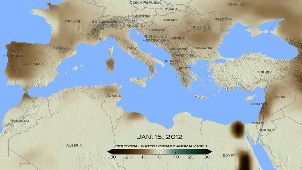
Mediterranean Drought Worst in 900 Years
A new NASA study used remote-sensing and tree-ring data to conclude that the recent drought that began in 1998 in the eastern Mediterranean Levant region (Cyprus, Israel, Jordan, Lebanon, Palestine, Syria and Turkey) is likely the worst drought of the last nine centuries.
