LIVERMORE, Calif., USA/ CAPELLE A/D IJSSEL, The Netherlands – Sokkia announces the largest forest management company in Latvia – Joint Stock Company “Latvia’s State Forests†(LVM) – chose its latest compact GNSS receivers for forest data collection. The...
Eos Announces Sub-Meter and RTK Solutions for Esri’s New Collector 10.4.0 for iOS
Eos Positioning Systems (Eos) announces Arrow GNSS receiver series compatibility with Esri's Collector for ArcGIS running on iPads and iPhones. The Arrow Series GNSS receivers have been tested and certified as high-accuracy GNSS receivers compatible with Collector...
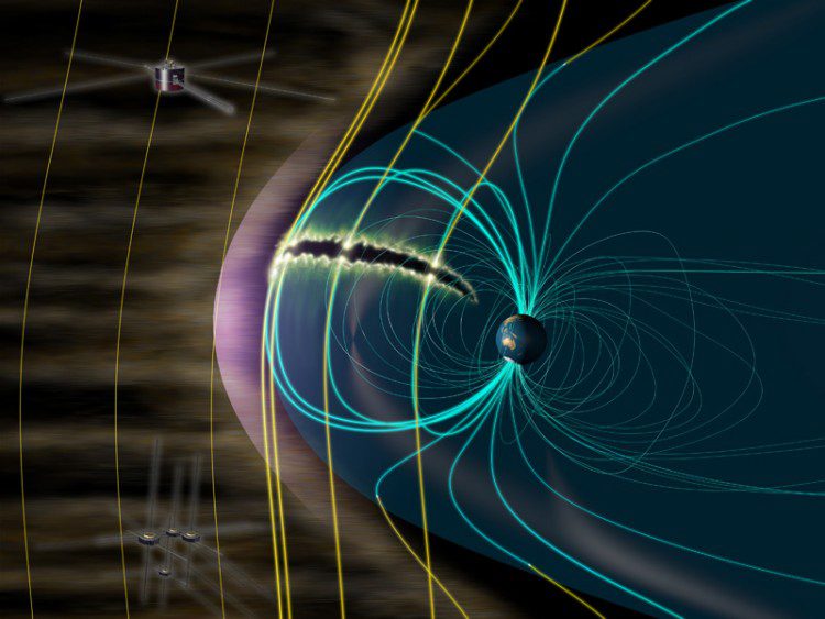
Satellites Find Source of Aurora Explosions
An international team led by Hiroshi Hasegawa and Naritoshi Kitamura (ISAS/JAXA) analyzed data taken by the U.S.-Japan collaborative GEOTAIL mission and NASA's MMS satellites, finding that the interaction between the magnetic fields of Earth and the Sun, or more precisely the phenomenon known as magnetic reconnection, can feed aurora explosions.
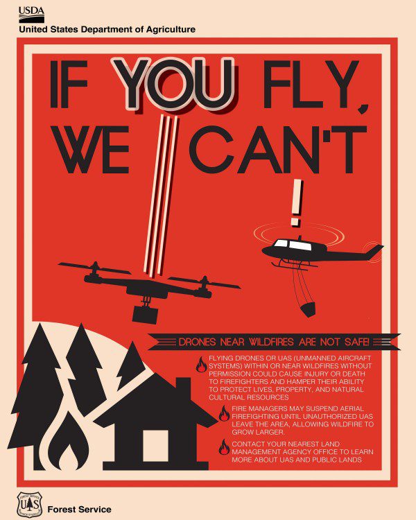
DOI, UAS Industry Partnering to Reduce Firefighting Interference
To address the growing problem of unmanned aircraft systems (UASs) impeding wildland firefighting efforts, the U.S. Department of the Interior and industry partners activated a prototype warning system that provides real-time alerts and geofencing alarms to prevent drone pilots from interfering with firefighting operations.
As Wildfire Season Continues to Heat up, Interior Partners with Industry to Eliminate Drone Intrusions
WASHINGTON, D.C. – To address the growing problem of unmanned aircraft systems (UAS) impeding wildland firefighting efforts, the U.S. Department of the Interior and industry partners activated a prototype warning system that provides real-time alerts and...
UAV Industry Taking Off
Karlsruhe, Hamburg 25 July 2016 - The new sector for hardware and software manufacturers and service providers in the UAS industry is incredibly dynamic. As part of INTERGEO in Hamburg from 11 to 13 October, interaerial SOLUTIONS will be showcasing the legal...
Geospatial Science Expert to Help Determine Greenhouse Gas Guidelines
FAYETTEVILLE, Ark. – A geospatial science expert at the University of Arkansas will help refine international guidelines for greenhouse gas inventories that will be considered for adoption by the Intergovernmental Panel on Climate Change. The panel, known as IPCC,...
Drone Industry Experts and Major Firms Are Set to Present at the UAS Summit & Expo
GRAND FORKS, ND - UAS Magazine announced this week the preliminary agenda for the 10th annual UAS Summit & Expo, the Upper Midwest's premier unmanned aircraft systems event produced by UAS Magazine and the Red River Valley Research Corridor. Taking place August...
World LiDAR Market Overview, By MarketIntelReports
According to a new research report by MarketIntelReports titled “Global LiDAR Industry 2016 Research Report†is a detailed qualitative analysis of the factors responsible for driving and restraining growth of the LiDAR Industry and future opportunities are...
Geospatial Minds for Society “ GI_Forum 2016 in Retrospect
GI_Forum 2016, the 10th annual conference along with its sister conference, AGIT and the German branch of FOSSGIS, was held at the University of Salzburg, Austria. It was organized by the Interfaculty Department of Geoinformatics - Z_GIS of the University of Salzburg,...
