Supergeo is pleased to announce that SuperSurv, one of the most well-known mobile GIS products of Supergeo, will soon leap forward to the next generation, SuperSurv 10! Available on iOS and Android mobile operating systems, SuperSurv is a mobile GIS app designed for...
Esri Unveils CityEngine Mobile Virtual Reality Solution
REDLANDS, Calif. — Global smart-mapping leader Esri today announced a virtual reality (VR) solution for CityEngine, the company's award-winning 3D modeling software. The newest version of CityEngine allows urban planners, architects, and GIS professionals to simply...
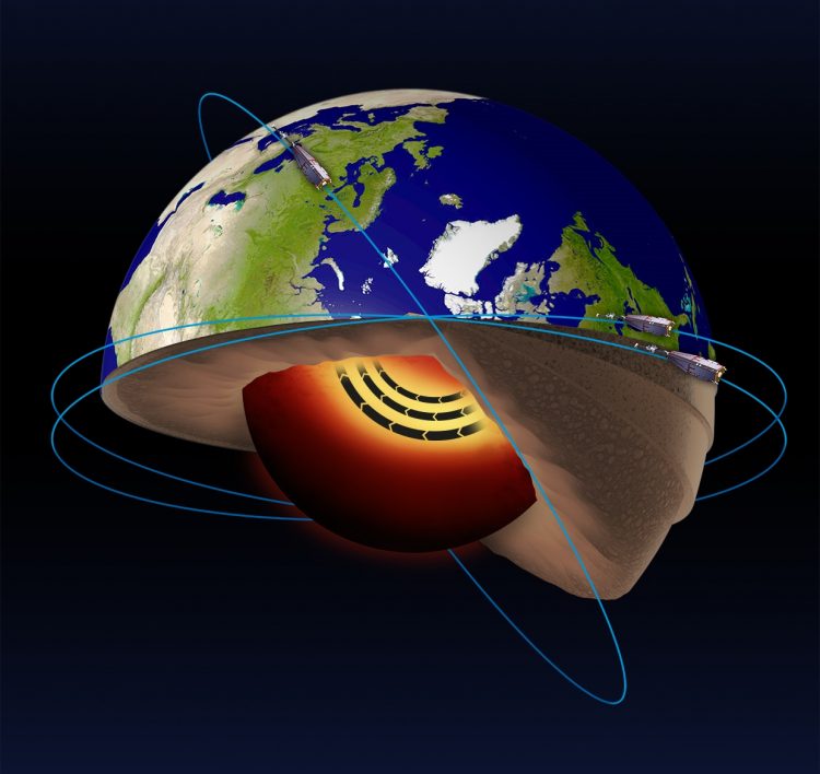
Swarm Satellites Discover ˜Jet Stream' in Earth's Core
Using data from the European Space Agency's three Swarm satellites”which measure the different magnetic fields that stem from Earth's core, mantle, crust, oceans, ionosphere and magnetosphere”scientists discovered a jet stream deep below Earth's surface that's increasing in speed.
CALL FOR PAPERS – GeoRich 2017 – ACM SIGMOD Workshop on Managing and Mining Enriched Geo-Spatial Data
Both the current trends in technology such as smart phones, general mobile devices, stationary sensors and satellites, as well as a new user mentality of utilizing this technology to voluntarily share information, produce a huge flood of geo-spatial data. This data is...
Dewberry Awarded Second Consecutive HGACBuy Contract
Dewberry, a privately held professional services firm, was recently awarded a three-year, all hazards preparedness, planning, consulting, and recovery services contract through the HGACBuy cooperative purchasing program. Services will be provided in the areas of...
New Esri ArcGIS Release Transforms Spatial Analytics
Esri, the global leader in spatial analytics technology, today announced the release of Esri ArcGIS 10.5, the next-generation analytics technology for innovative organizations. Esri ArcGIS 10.5 arrives at a time when organizations worldwide are challenged to make...
Illinois Wesleyan University Selects Geospatial Corporation’s GeoUnderground and GIS-Centric Smart-Asset Management Technologies
PITTSBURGH -Â Geospatial Corporation (OTCQB Symbol "GSPH"), a leading innovator of asset management/analytics/mapping software and 3D mapping technologies, announced today that Illinois Wesleyan University has chosen the Company's industry leading GeoUnderground...
Autodesk BIM 360 Docs Now Available For Android Devices
If you attended Autodesk University in Las Vegas in November, you’ll recall that during the Product Innovation Keynote, Sarah Hodges, Autodesk’s Construction Business Line Director, made reference to upcoming BIM 360 Docs support for Android devices. That day has...
Global Geospatial Outlook Report to be Released at Geospatial World Forum 2017
Noida, India – Geospatial technology is changing rapidly and finding use in virtually every economic sector globally. It is considered one of the most important high-growth industries of the 21st century. But then, what does the geospatial industry encompass and...
XDynamics to Launch World’s First UAV with Zero Latency Live View and Dual-Screen Controller at CES 2017
HONG KONG — XDynamics Evolve, the world's first consumer drone completed with zero latency Full HD live view and dual-screen remote controller will make its official debut at CES 2017, in Las Vegas, January 5-8. High resolution images of Evolve drone to...
