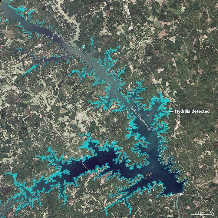
Swarm Satellites Discover ˜Jet Stream' in Earth's Core

Swarm Satellites Discover ˜Jet Stream' in Earth's Core

Using data from the European Space Agency's three Swarm satellites”which measure the different magnetic fields that stem from Earth's core, mantle, crust, oceans, ionosphere and magnetosphere”scientists discovered a jet stream deep below Earth's surface that's increasing in speed.

ESA Commits 10 Billion Euros to Space Activities

ESA Commits 10 Billion Euros to Space Activities

In early December 2016, the European Space Agency (ESA) held a two-day council meeting in Lucerne, Switzerland, where ministers from ESA's 22 member states plus Slovenia and Canada allocated €10.3 billion for space activities and programs based on the vision of a United Space in Europe in the era of Space 4.0.

WorldView-4 Successfully Launched

WorldView-4 Successfully Launched

On Nov. 11, 2016, DigitalGlobe's WorldView-4 commercial imaging satellite was launched aboard an Atlas V rocket from Vandenberg Air Force Base, Calif. About 45 minutes after launch, satellite signals indicated it was in proper position and working order.

Sentinel Hub Web Service Wins 2016 Copernicus Masters Competition

Sentinel Hub Web Service Wins 2016 Copernicus Masters Competition

On Oct. 25, 2016, winners in the Copernicus Masters Earth-observation competition were recognized before an international audience in Madrid, Spain. The grand prize went to the team from Slovenia's Sinergise Ltd., whose Sentinel Hub cloud-based web service for satellite data won the T-Systems Open Telekom Cloud Challenge before edging out winners of the other six categories.

NASA Establishes Small Spacecraft Systems Virtual Institute

NASA Establishes Small Spacecraft Systems Virtual Institute

NASA introduced the Small Spacecraft Systems Virtual Institute (S3VI), hosted at NASA's Ames Research Center in Moffett Field, Calif., to leverage the growing small spacecraft (i.e., SmallSat) community, promote innovation, identify emerging technology opportunities, and provide an efficient channel for communication about small spacecraft systems with industry, academia and other government agencies.

Satellite Imagery Helps Verify ˜Zero Deforestation' Commitments

Satellite Imagery Helps Verify ˜Zero Deforestation' Commitments

Airbus Defence and Space, The Forest Trust (TFT) and SarVision developed the Starling service, which enables companies to provide evidence of how they're implementing their No Deforestation commitments. Starling uses a combination of high-resolution optical satellite and radar imagery to provide unbiased monitoring of forest-cover change.

NEWEST V1 MEDIA PUBLICATION

April Issue 2024