Earlier this week, Spacemetric signed a reseller agreement with an undisclosed European vendor of intelligence, surveillance and reconnaissance (ISR) aircraft systems. Spacemetric’s Keystone geospatial image processing library will be integrated in vendor’s ISR...
Esri’s Dawn Wright Celebrates Earth Day by Speaking at EarthxOcean Conference
REDLANDS, Calif.— Esri, the global leader in spatial analytics, today announced that Dr. Dawn Wright, Esri chief scientist, will speak at the EarthxOcean Conference being held April 20 through 23 in Dallas, Texas. Presented by Mission Blue and EarthX, the conference...
GEO Jobe to Share “The Power of GIS, Simplified” at the 2018 TNGIC Conference
NASHVILLE, Tenn. - We're pleased to share that some of the GEO Jobe crew will be on the road this month, this time making a stop in Burns, TN for the annual TNGIC, Tennessee Geographic Information council conference. The event takes place in Burns, TN at...
New Indoor Mobile Mapping System from NavVis Marks Breakthrough in Data Quality
NavVis, a global leader in mobile indoor mapping, visualization, and navigation, announces the launch of M6, a next-generation indoor mobile mapping system that overcomes the scalability and data quality constraints of today’s reality capture technology. Surveyors...
Boundless Enables Real-Time Mobile Data Collection with Boundless Anywhere
St. Louis, MO – Boundless, the leader in open GIS, today introduced Boundless Anywhere™, a new application for enterprises needing to collect and distribute location information from handheld devices and tablets. With Boundless Anywhere, organizations can...
New Additions, Upgrades to FLIR Premiere Handheld HD Cameras
WILSONVILLE, OR – FLIR Systems, Inc. (NASDAQ: FLIR) today announced the release of the FLIR T1010 -  a new addition to the T1K series of HD thermal imaging cameras. This latest model includes software upgrades that will make all T1K series cameras more responsive...
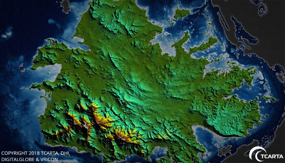
Satellite-Derived Surface Models Used for Caribbean Disaster Recovery
TCarta delivered pre- and post-disaster surface models for the Caribbean islands of Antigua and Barbuda for use in Hurricane Irma recovery efforts.

The Aurora and the Sunrise
Auroras are one of the many Earthly phenomena the crew of the space station observe from their perch high above the planet.
HawkEye 360 Expands Advisory Board with the Addition of The Honorable Robert Work, Former U.S. Deputy Secretary of Defense, and Lieutenant General (Ret.) John F. Mulholland Jr.
HawkEye 360, Inc. today announced an expansion of its advisory board to include two new members, The Honorable Robert Work, who recently served as U.S. Deputy Secretary of Defense, and Lieutenant General (Ret.) John F. Mulholland Jr., as well as the appointment of...
American Association of Geographers Honors Esri’s Allen Carroll with Media Achievement Award
REDLANDS, Calif.- Esri, the global leader in spatial analytics, today announced that Allen Carroll, leader of the Esri Story Maps team, has been given the Media Achievement Award for 2018 by the American Association of Geographers (AAG). At Esri, Carroll and his team...
