MOUNTAIN VIEW, Calif.- Elastic N.V. (NYSE: ESTC), the company behind Elasticsearch and the Elastic Stack, announced the general availability of version 6.7 of the Elastic Stack. This release delivers two new solutions: Maps, for advanced, layered visualization of...
Pond5 and DJI Expand Premium Aerial Footage Collection With New Content From Around the World
Following last year’s much-heralded launch of thePond5 DJI premium footage collection, global content marketplacePond5andDJI, the worlds leading manufacturer of civilian drones and aerial imaging technology, have expanded the in-demand offering to include a wealth...
Innoviz Technologies Raises $132M in Series C Funding to Accelerate Solid-State LiDAR Production, Expand Team and Further R&D Efforts
ROSH HA’AYIN, Israel – Innoviz Technologies, a leading provider of high-performance, solid-state LiDAR sensors and perception software, announced today that it has raised $132 million in Series C funding. The round is marked by the entrance of new major...
Space Flight Laboratory to Build HawkEye 360 Next-Gen Microsatellite Cluster for Commercial Radio Frequency Geolocation
TORONTO, March 27, 2019 - Space Flight Laboratory (SFL) has been awarded the prime contract to develop the next generation cluster of formation-flying microsatellites for HawkEye 360 Inc. of Herndon, Va. The HawkEye Constellation, comprised of multiple clusters of...
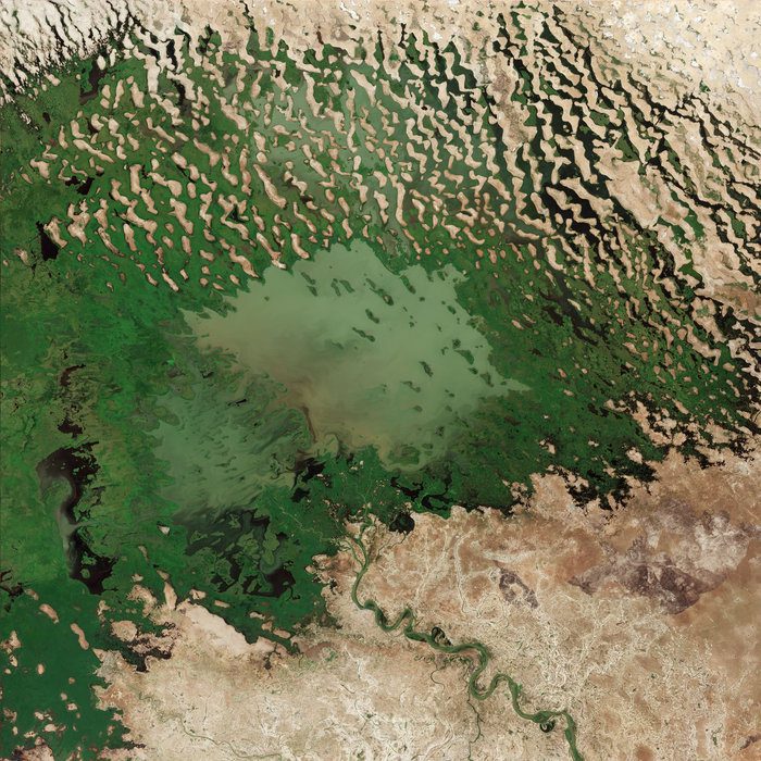
Lake Chad's Shrinking Waters
This image from the Copernicus Sentinel-2A satellite takes us over Lake Chad at the southern edge of the Sahara, where water supplies are dwindling.
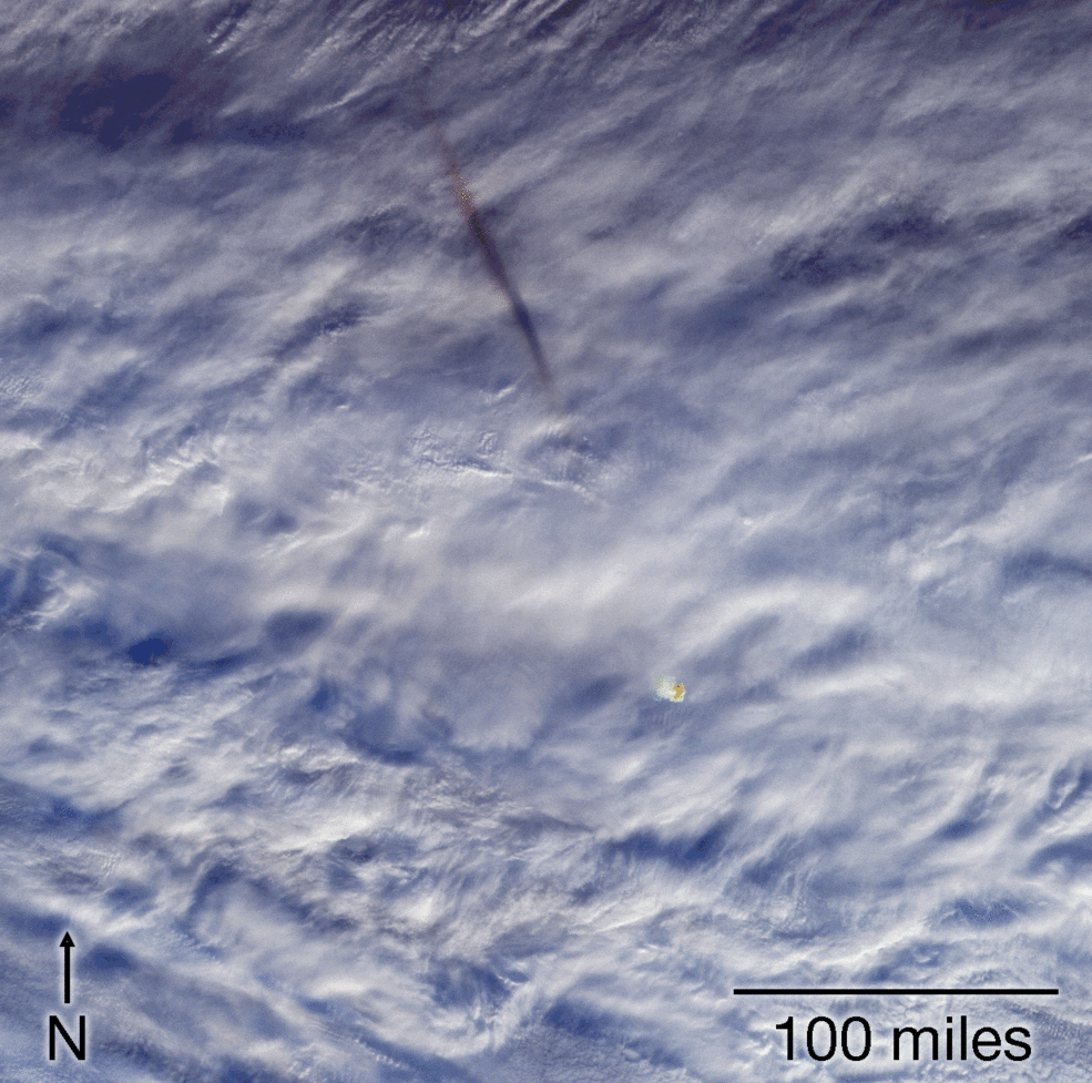
NASA Instruments Image Fireball over Bering Sea
The explosion unleashed an estimated 173 kilotons of energy”more than 10 times the energy of the atomic bomb blast over Hiroshima during World War II.
GeoSpock and X-Locations collaborate to deliver next generation location data analysis in Japan
GeoSpock – the extreme-scale spatial big data integration company that provides analytics, builds insight, and enables predictions across space and time – announced a new partnership with X-Locations – the Japan-based location AI platform company. The companies...
James Fee Joins the Spatial Networks Team as Vice President for Professional Services
Spatial Networks (SNI), a fast-growing geospatial information and technology firm headquartered in St. Petersburg, FL, is excited to announce the addition of James Fee to the leadership team. Fee joins as Vice President for Professional Services, responsible for the...
Ouster announces significant lidar business milestones, additional $60M funding, adds to board of directors
SAN FRANCISCO -Â Ouster, a leading provider of high-resolution lidar sensors used for autonomous vehicles, robotics, and mapping today announced significant business momentum including a roster of over 400 customers and the addition of over $60 million in funding. The...
New Emlid Reach RS2 Multi-band RTK GNSS Receiver
Emlid, the creators of Reach, centimeter-accurate RTK GNSS receiver, launched pre-orders for their multi-band GNSS receiver Reach RS2. The new receiver features built-in LoRa radio, 3.5G modem and a survey app for iOS and Android. L1/L2/L5 RTK GNSS receiver with...
