The upcoming release of NavVis IndoorViewer 3D building visualization software will include a new feature to select, crop and download point cloud sections in browser. The beta version of the extended point cloud functionality in NavVis IndoorViewer will be previewed...
Avineon to Demonstrate Model Manager at Esri GeoConX Conference
McLean, Virginia – Avineon, Inc. (Avineon), a global provider of information technology and engineering support services, will be presenting new enhancements to its portfolio of geospatial offerings during the 2019 Esri GeoConX Conference at the Cobb Galleria...
Virtual Surveyor to Unveil Enhanced Cut-and-Fill Mapping in Drone Surveying Package at InterGEO 2019
LEUVEN, Belgium – Virtual Surveyor has added cut-and-fill mapping capabilities to Version 7.0 of its popular drone surveying package. The new functionality enables users to quickly perform volume difference calculations and generate cut-and-fill maps from drone...
Hexagon to showcase its Smart Buildings & Infrastructure and Smart Cities & Nations portfolios at INTERGEO 2019
Hexagon AB, a global leader in sensor, software and autonomous solutions, is showcasing its Smart Buildings & Infrastructure and Smart Cities & Nations portfolios at the INTERGEO expo and conference in Stuttgart, Germany, 17-19 September. The event’s theme,...
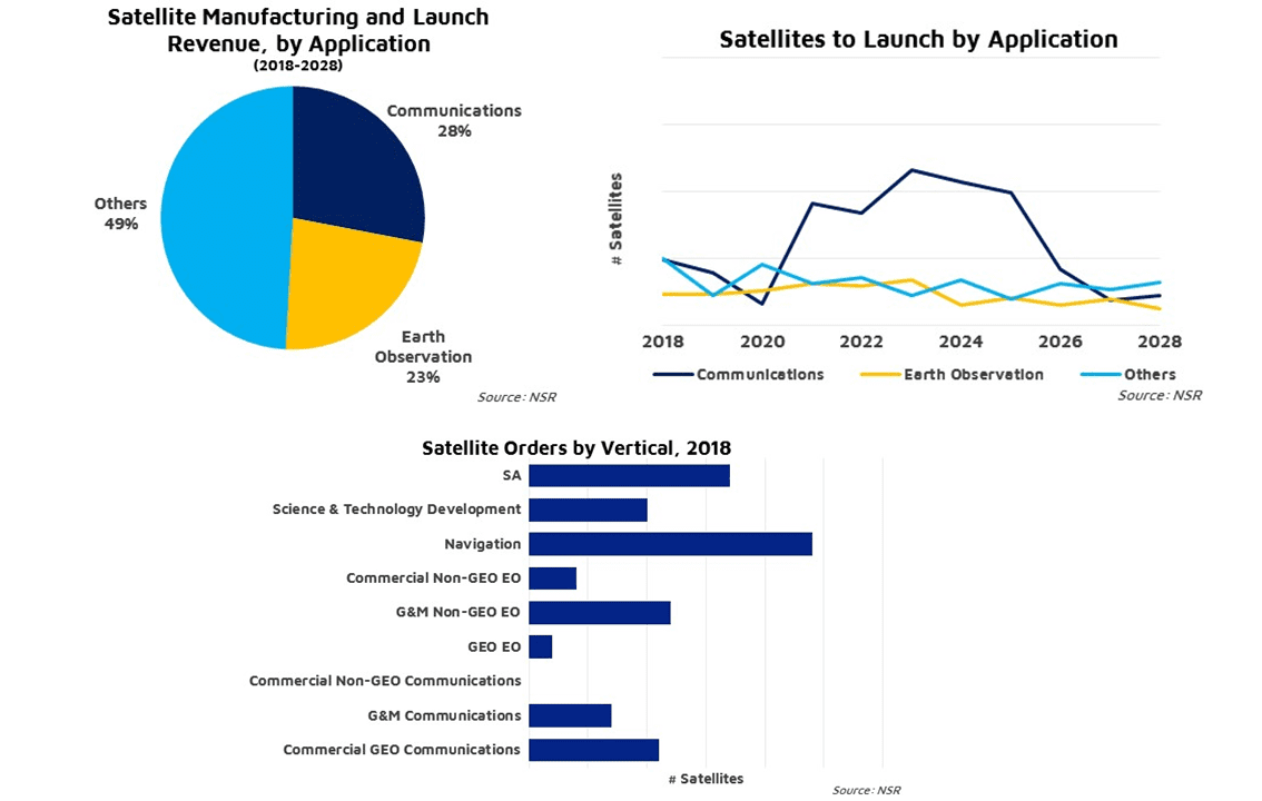
NSR Report Finds Large(r) Satellites Still a Long-Term Growth Market
Between end-of-life replacement demand from most government and military applications, such as situational awareness, and new demand from science and communications applications, the market for satellite launch and manufacturing is expected to grow robustly over the next decade.
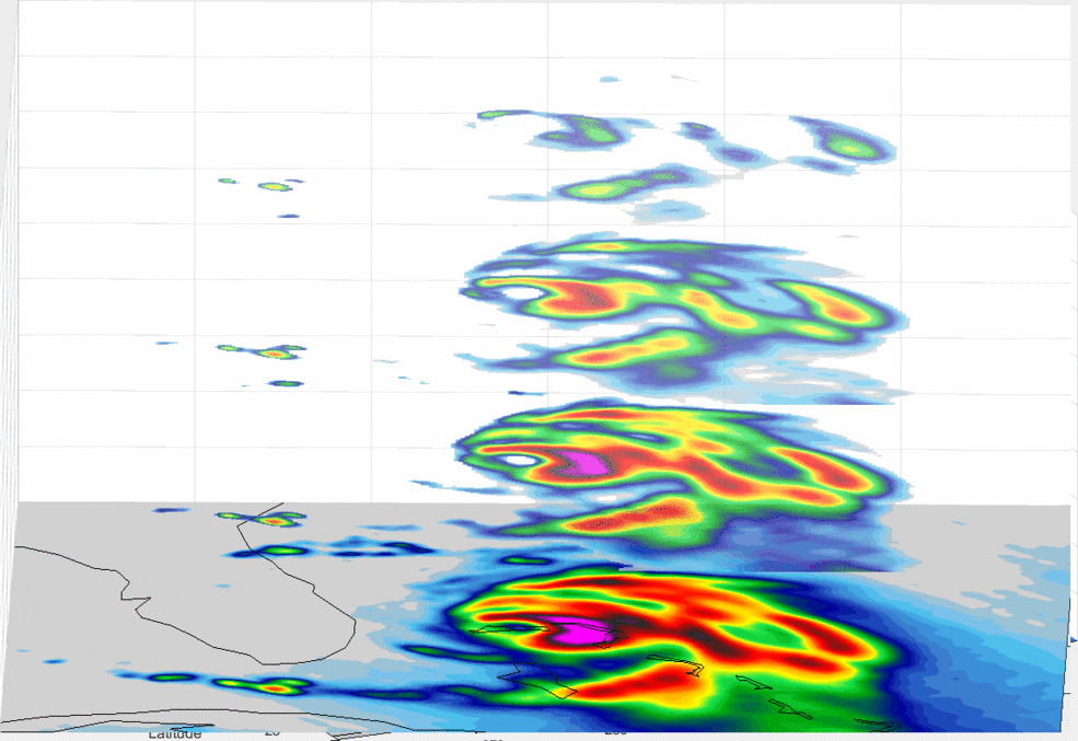
An Inside Look at Hurricane Dorian
A new view of Hurricane Dorian shows the layers of the storm, as seen by an experimental NASA weather satellite that’s the size of a cereal box.
NSR Report Finds Large(r) Satellites Still a Long-Term Growth Market
CAMBRIDGE, Mass.- NSR’s Satellite Manufacturing and Launch Services, 9th Edition report finds despite a few slow years, 1,155 satellites over 500 kg are expected to be ordered, with 1,285 to be launched, in the next decade. Between end of life replacement demand...
Flirtey unveils the future of drone delivery with never-before-seen video and images of its latest industry-leading drone and technology with Senator Catherine Cortez Masto at The National Press Club in Washington, D.C.
WASHINGTON - Flirtey, the pioneer of the commercial drone delivery industry, has unveiled the Flirtey Eagle, the world's most advanced drone delivery technology today with Senator Cortez Masto (D-NV) at The National Press Club in Washington, D.C. The company has...
Satellogic Signs Agreement to Deliver Dedicated Satellite Constellation for Exclusive Geospatial Analytics in Henan Province, China
UENOS AIRES – Satellogic, the world’s first vertically integrated geospatial analytics company, today announced that they have partnered with ABDAS, based in Henan Province, China, to deliver exclusive access to a dedicated constellation of satellites. The total...
SiriusXM Marine Launches Fish Mappingâ„¢ Service – Now Available on Garmin® GXMâ„¢ 54 Satellite Weather and Radio Receiver
NEW YORK - SiriusXM today announced the launch of its new Fish Mapping™ service. This new, comprehensive SiriusXM Marine package – designed to help saltwater anglers locate fish faster, as well as save time and fuel – is now available on the GXM 54 satellite...
