Aerial Image Shows Remains of Joplin High School

Aerial Image Shows Remains of Joplin High School

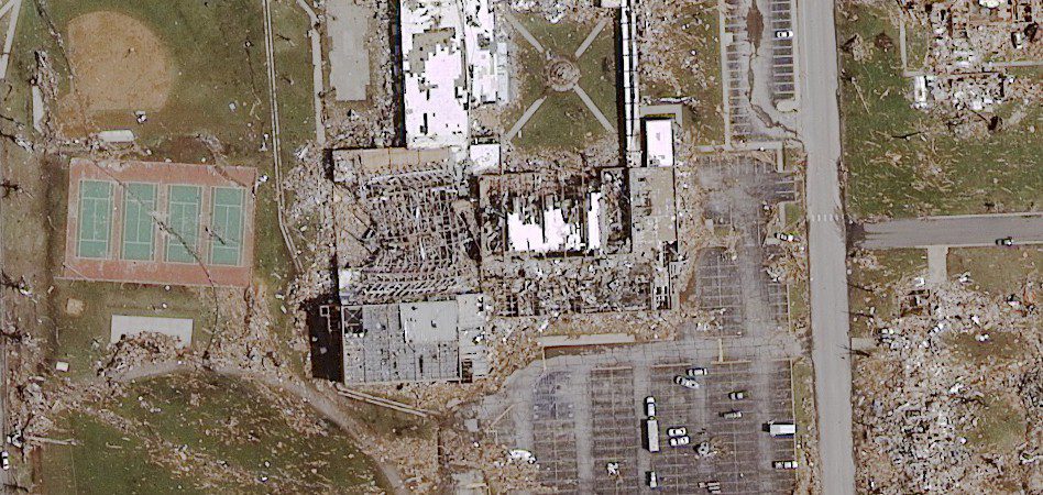
This one-foot resolution, digital aerial image of Joplin, Mo., was collected May 24, 2011, at approximately 9:30 a.m. The image shows the remains of Joplin High School, located at 21st and Indiana, just two days after a Level 5 tornado touched down on May 22, 2011 and...

Imagery in the News Departments May June

Drought and Heat Create Hazardous Fire Conditions in Texas  So far in 2011, more than 1.4 million acres have burned in Texas. Some 800 fires have occurred throughout the state, burning 401 structures and costing two firefighters their lives. Why is fire activity so...

Onekotan Island, Kuril Islands, Russian Federation

Snow cover highlights the calderas and volcanic cones that form the northern and southern ends of Onekotan Island, part of the Russian Federation in the western Pacific Ocean. Calderas are depressions formed when a volcano emptiesits magma chamber in an explosive...

Tassili n'Ajjer National Park

Tassili n’Ajjer National Park covers 72,000 square kilometers (27,800 square miles) in southeastern Algeria. Part of the Sahara Desert, the park has a bone-dry climate with scant rainfall, yet does not blend in with Saharan dunes. Instead, the rocky plateau rises...

Industry Updates May-June

Japanese Satellite Fails While Imaging Tsunami Wreckage   Japan’s Advanced Land Observing Satellite (ALOS) may be lost after losing power April 22, 2011, while mapping the nation’s devastated coast. Engineers at the Japan Aerospace Exploration Agency (JAXA)...

Beware”Map Projections Do Matter

By Robert Simmon, NASA Goddard Space Flight Center (www.nasa.gov/goddard), Greenbelt, Md. hen it comes to misinterpreting a satellite image or map, there are many ways the media and other organizations can get it wrong. For example, consider this recent headline and...

Stay in Control!

Accurate and precise ground control is essential to successful mapping projects. By Jeff Specht, publisher, Earth Imaging Journal (https://eijournal.com/), Greeley, Colo. Imagine you’re about to spend $2,000 on a new Armani wool suit. Wouldn’t you expect an...

Modeling the World

Image processing innovations are creating value for decision makers. By Robert Schowengerdt, professor emeritus, University of Arizona (http://www.arizona.edu/),  Tucson, Ariz. He is the author of Remote Sensing—Models and Methods for Image Processing (2006), which...

Data Fusion Expands Intelligence Options

By James. S. Blundell, vice president, Geospatial Products and Solutions, Overwatch Systems (http://www.overwatch.com/), Sterling, Va. Remote sensing, in all its varied forms and functions, has continually evolved, from the Civil War-era fixed balloons with spotters...

NEWEST V1 MEDIA PUBLICATION

April Issue 2024