March 16, 2016
The U.S. Geological Survey and the European Space Agency (ESA) have established an innovative partnership to enable USGS storage and redistribution of Earth observation data acquired by Copernicus program satellites. The ESA-USGS collaboration will serve scientific and commercial customers who are interested in the current conditions of forests, crops, and water bodies across large regions
March 15, 2016
To commemorate the nation's first chief geographer, the USGS established the Henry Gannett Award. This year's recipient is Nicholas Mastrodicasa, Alaska Department of Transportation & Public Facilities, for his leadership in the Alaska Statewide Digital Mapping Initiative and the development of an elevation requirements study for Alaska. “Over the last 10 years, Nick has been
March 14, 2016
The U.S. Geological Survey has created 20 new flood inundation maps that can help South Carolinians take steps to prevent or reduce future flood damage in the areas affected by the widespread floods of October 2015. The maps, which document the extent and depth of last autumn’s floodwaters in a dozen central and coastal South
March 14, 2016
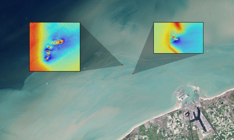
Using data from the NASA/USGS Landsat 8 satellite, researchers have detected sediment plumes extending as far as four kilometers downstream from shallow shipwreck sites, demonstrating how satellites may be used to locate the watery graves of coastal shipwrecks.
March 10, 2016
The U.S. Geological Survey has announced the first recipients of the 2016 partnership funding awards for the 3D Elevation Program. This program, referred to as 3DEP, presents a unique opportunity for collaboration between the USGS and other federal, state and local agencies to leverage the services and expertise of private sector mapping firms that acquire
February 25, 2016
To demonstrate the potential of using remote sensing to monitor water quality across broad areas, U.S Geological Survey and NASA scientists teamed up for the simultaneous collection of water quality measurements from the air and in the water. While USGS scientists collected water quality measurements from a boat in the northeastern part of San Francisco
February 12, 2016
A new series of maps of fog and low clouds covering the northern and central California coasts reveals daytime and nighttime patterns with a level of detail never previously mapped. U.S. Geological Survey scientists used new analyses of satellite images to understand the dynamics of fog. Fog and low clouds have a significant influence on
February 10, 2016
The USGS National Map program is transitioning all of its GIS data download capabilities to its new TNM Download client during the week of February 15, 2016. The new launch page will help users easily find the variety of resources available to get National Map data, download GIS data, visualize and analyze data on the
February 4, 2016
Dewberry, a privately held professional services firm, was selected by the U.S. Geological Survey (USGS) to collect and process topographic lidar data of Puerto Rico and the islands of Culebra, Vieques, and Isla de Mona. Falling under the USGS' Geospatial Product and Services Contract and co-funded by the Commonwealth of Puerto Rico, the data will