Leicestershire, October 7, 2015 — Bluesky has completed a multi-million pound aerial mapping project to assess the impact of vegetation on the electricity network of East Anglia and the South East of England. Working on behalf of UK Power Networks, Bluesky...
Potree Puts Big and Beautiful LiDAR in Your Browser
September 14, 2015 — Just in time for INTERGEO 2015, the Potree software was released in its latest 1.3 version. Potree is a WebGL based point cloud viewer for very large datasets. The Potree software allows to publish large LiDAR point clouds on the Web such that...
Teledyne Optech Showing Latest Mine Surveying Tools at EXPOSIBRAM
September 9, 2015 — Teledyne Optech is pleased to announce that several of its latest lidar solutions for mine surveying will appear at the International Mining Exhibition (EXPOSIBRAM) 2015 in Brazil on September 14-17 at booth C22. Visitors to the Teledyne Optech...
SBG SYSTEMS Joins VIAMETRIS to Present the New Generation of 3D Indoor Scanning System Aided by the Ellipse-A AHRS
Rueil-Malmaison, France, September 8, 2015 – SBG SYSTEMS joins VIAMETRIS to present at the INTERGEO trade show, the new generation of the “iMMSâ€, called now “iMS 3Dâ€, a mobile 3D indoor scanner generating continuous 3D point clouds. For this brand new model,...
Richmond International Airport Hires Timmons Group to Design and Implement Enterprise GIS
Richmond, VA, September 4, 2015 - The Richmond International Airport (RIC) contracted with Timmons Group, a national geospatial consulting firm to design and implement an Enterprise GIS. The Enterprise GIS will support Federal Aviation Administration (FAA) Airports...
Europe LiDAR Market By Product Type, By Application, and By Geography – Analysis and Forecast (2014-2019)
NEW YORK, September 3, 2015 - The term 'LiDAR' is an acronym for 'Light Detection and Ranging', which has been derived from the common term 'RADAR'. LiDAR technology has been around in the military and research circles, since the early 1960s. A typical LiDAR system...
Capturing Reality Forum Receive Overwhelming Response to Call for Papers!
August 25, 2015 — The Capturing Reality Forum focuses on the technologies of laser scanning, LiDAR and 3D data capture, combining the best of SPAR Europe and ELMF. The conference committee are delighted to report an overwhelming response to the Call for Papers with...
ASPRS Launches New Lidar Certification
Bethesda, Md., August 19, 2015 — The American Society for Photogrammetry and Remote Sensing (ASPRS) certification program announces the launch of a Professional and Technologist LIDAR Certification, the Certified Mapping Scientists, Lidar (CMS, Lidar) and the...
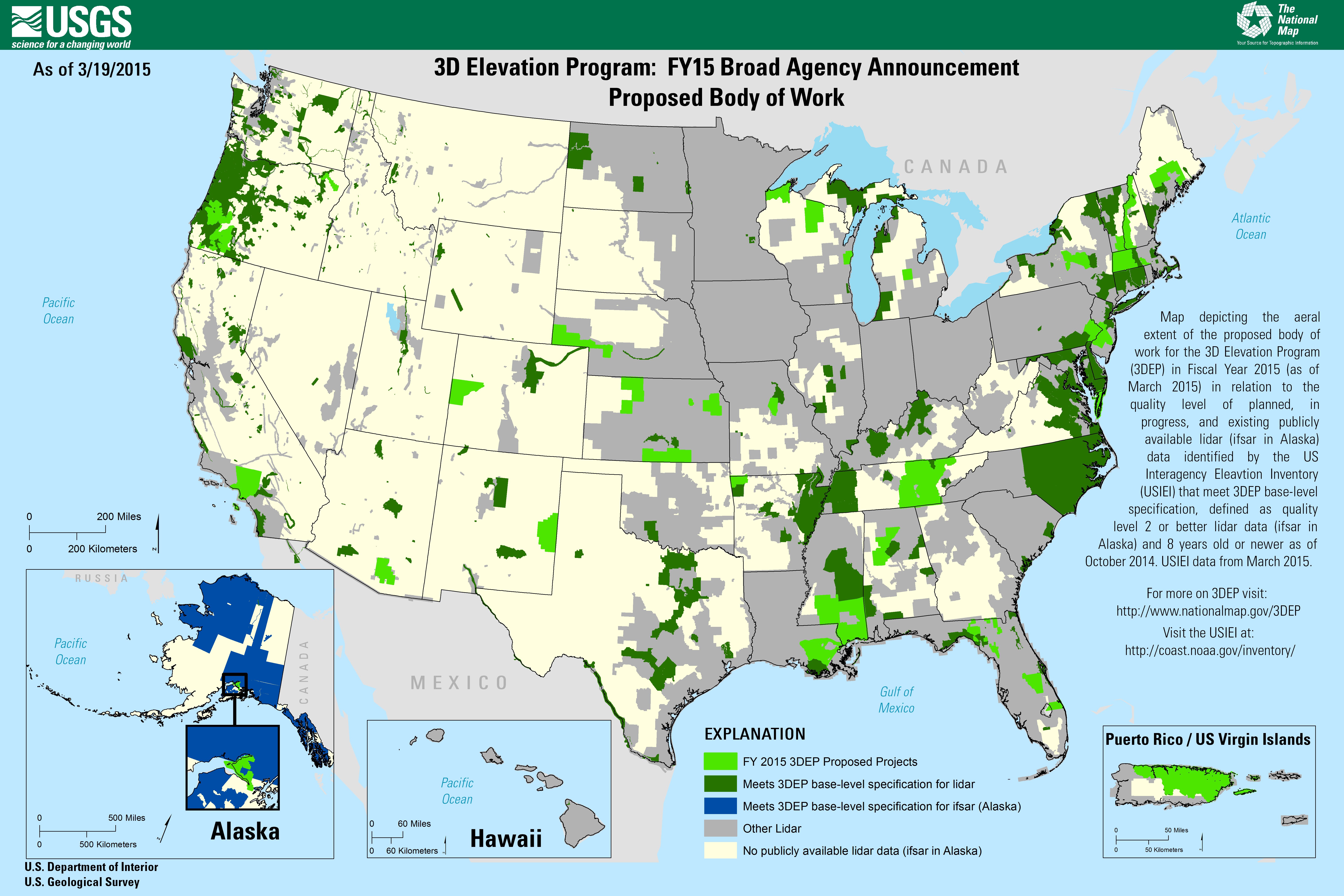
Dewberry to Evaluate New LiDAR Technologies for 3DEP
Under its Geospatial Products and Services Contract with the U.S. Geological Survey (USGS), Dewberry is executing a task order to evaluate two new forms of LiDAR to determine if single-photon LiDAR (SPL) and Geiger-mode LiDAR (GML) can satisfy USGS LiDAR Base Specification version 1.2 for quality level (QL2) LiDAR for use in the USGS 3D Elevation Program (3DEP).
Woolpert Selected by USGS to Evaluate New Lidar Technologies for 3DEP
DENVER, August, 13, 2015 — The U.S. Geological Survey (USGS) has contracted with Woolpert to evaluate new lidar (light detection and ranging) technologies to assess the suitability to support the 3D Elevation Program (3DEP). This use of the single photon and Geiger...
