HOUSTON, Texas – April 4, 2017 – Bechtel, a global leader in engineering, procurement, and construction, announced today that the firm has entered into an agreement with SKUR, the construction industry’s pioneer in providing insights focused on actual on the...
Dewberry Selected to Provide QA/QC of Maine Map Data
Dewberry, a privately held professional services firm, has been selected by the Maine GeoLibrary and Maine Office of GIS (MeGIS) to provide an independent review of lidar acquisition procedures, lidar data, and final deliverables for 8,743 square miles in eastern and...
Ordnance Survey Sets Out to Enhance its Aerial Mapping Technologies
Ordnance Survey (OS) has signed an agreement with the Defence Science and Technology Laboratory (Dstl), negotiated by its technology transfer arm, Ploughshare Innovations, to allow it to licence various forms of cutting edge aerial mapping technology. The main...
Launch of IXmaps Internet Mapping Tool Enables Canadians to See Exactly Where their Data Travels Online
OTTAWA - The launch of a powerful Internet Mapping tool means Canadians now have an easy way to track exactly where their data is traveling across the Internet. The tool at IXmaps.ca — IXmaps stands for Internet Exchange Mapping — is the brainchild of a team of...
Phase One Industrial and ATI Set to Revolutionize Aerial Inspection of Critical Infrastructure
COPENHAGEN, Denmark-Â Phase One Industrial and Aerial Technology International (ATI) have developed a powerful professional aerial inspection tool that could help revolutionize the way commercial and industrial structural visual inspections are done. An integrated ATI...
Blue Marble Adds Flat Earth Support to Geographic Calculator
Hallowell, Maine - As an acknowledgment of the diversity of opinions that have recently been expressed about the shape and structure of the earth, Blue Marble is pleased to announce that it is updating its flagship geodetic software, Geographic Calculator, to...
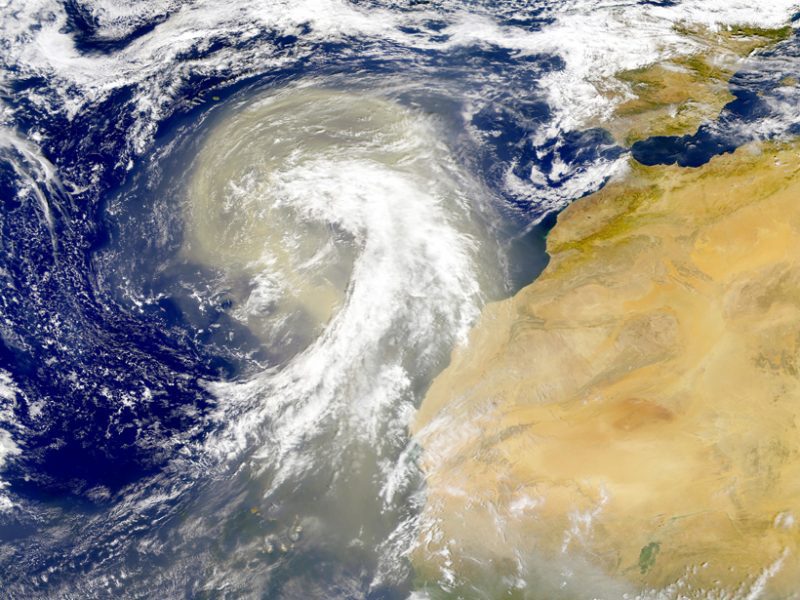
Satellite Data Reveal Effects of Aerosols
Earth's atmosphere is dusted with tiny particles known as aerosols, which include windblown ash, sea salt, pollution, and other natural and human-produced materials. Aerosols can absorb or scatter sunlight, affecting how much light reflects back into space or stays trapped in the atmosphere.
National Geospatial-Intelligence Agency Selects Esri for eNGAge Program
Redlands, California—Esri, the global leader in spatial analytics, today announced that the National Geospatial-Intelligence Agency (NGA) has selected Esri to participate in the agency's eNGAge program. The initiative builds the agency's internal knowledge and...
The Getech Group is Set to Explore and Innovate with Esri
Exprodat, a Getech Group Company, that provides natural resources insight, data and expertise to companies and governments around the world, will be a Sapphire Sponsor of the forthcoming Esri Petroleum GIS Conference. Held in the George R Brown Convention Center,...
New DroneDeploy Report Reveals Drone Industry Trends Across 160 Countries
SAN FRANCISCO, CA - DroneDeploy, the leading cloud software platform for commercial drones revealed its third Commercial Drone Industry Trends Report, representing analysis of more than 10 million acres mapped by drone users in more than 160 countries across all seven...
