REDLANDS, Calif.- Esri, the global leader in spatial analytics, today announced the release of significant enhancements to the World Geocoding service for the company's ArcGIS platform. This update to the World Geocoding service gives users access to 25 additional...
Nearmap Delivers New 3-D Content and Oblique Imagery, Transforming Location Content for the Mapping, Construction, Engineering and Government Industries
SOUTH JORDAN, Utah & SAN DIEGO - Nearmap today revolutionized the aerial imagery market by announcing a national survey program providing true, high-resolution oblique imagery and derivative 3-D products. Nearmap is already a global leader in providing cloud-based...
Esri Adds Airbus Global Elevation Data to Online Maps
REDLANDS, Calif.- Esri, the global leader in spatial analytics, today announced that Airbus Defence and Space WorldDEM4Ortho elevation data is soon to be part of the growing ArcGIS Online Living Atlas of the World. Covering the entire earth's land surface, this is the...
USGIF Appoints New Director of Academic Programs
Herndon, VA — USGIF hired Dr. Camelia Kantor, formerly an associate professor of geography at Claflin University in South Carolina, as its new director of academic programs. Kantor joins the Foundation with nine years of experience in college level teaching, course...
MAPSearch Launches ENvision Solar
TULSA, Okla.-Â ENvision, MAPSearch's online mapping platform, enables anyone to quickly locate, display, and analyze energy infrastructure using the same quality data licensed to our GIS customers. ENvision's easy-to-use platform is flexible and customizable, and its...
Esri's New ArcGIS 10.5 Enterprise Architecture Powers DigitalGlobe's Imagery+Analytics Offering
Esri, the global leader in spatial analytics, today announced that DigitalGlobe, the global leader in Earth imagery and information about our changing planet, has selected Esri’s ArcGIS 10.5 Enterprise architecture to deliver a new subscription product offering,...
Global Mapper SDK and LiDAR Module SDK v18.2 Released with Support for Cloud-Based Data Management Using Amazon Simple Storage Service
Hallowell, Maine - Blue Marble Geographics ( www.bluemarblegeo.com) is pleased to announce the immediate availability of version 18.2 of the Global Mapper Software Development Kit (SDK) along with the Global Mapper LiDAR Module SDK. Released in conjunction with the...
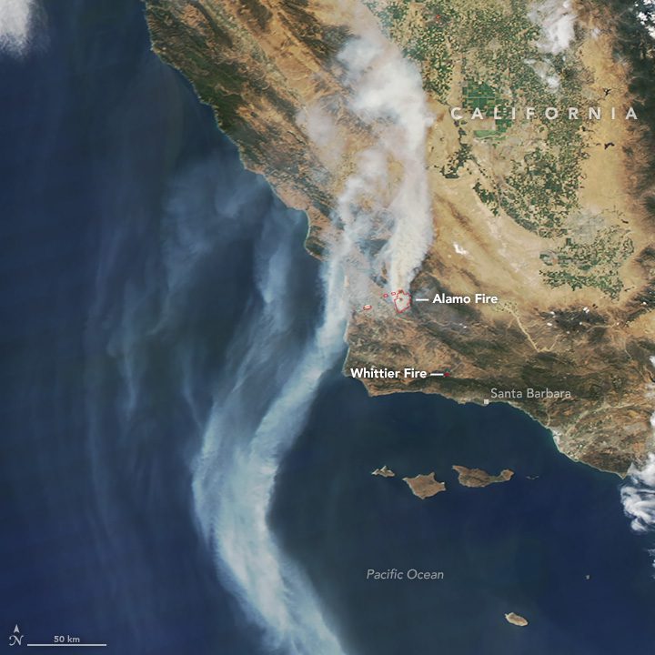
Satellites See One Fire, Two Plumes
In July 2017, sweltering temperatures and strong winds fueled intense wildfires in southern California. The fires forced thousands of people to flee their homes, charred dozens of structures, closed roads and darkened skies throughout the region with thick smoke.
Iridium Poised to Make Global Maritime Distress and Safety System History
MCLEAN, Va., July 11, 2017 - Iridium Communications Inc. (NASDAQ:IRDM) announced today that two key milestones along the path to becoming the second recognized provider of Global Maritime Distress Safety System (GMDSS) services have been reached. During its 98th...
Huron Geomatics Inc. Acquires Optech Maverick Mobile Mapping System
July 11, 2017 — Teledyne Optech is pleased to announce that Huron Geomatics Inc. (HGI)  has acquired an Optech Maverick mobile mapping system that will greatly support the expansion of the company’s operations. HGI provides breakthrough DSM/DTM modelling,...
