Munich, 02 August 2017 - GAF customers in Germany, Europe and worldwide can now access Planet’s substantial portfolio of optical satellite data, as well as derived value-added products, through a new partnership. According to GAF’s CEO, Dr. Peter Volk, the...
Most innovative Flight Zone in Europe, Startup Session and the Presentation of the First Drone Pioneer Award Address Especially Young Entrepreneurs at IASEXPO
Berlin/Karlsruhe - From 26 to 28 September 2017, the international UAV sector will be demonstrating its potential at INTERAERIAL SOLUTIONS in Berlin. Europe's largest drone show will form part of INTERGEO, the world's leading trade fair for geodesy, geoinformation and...
PacArctic LLC Wins U.S. Fish and Wildlife Service Contract in Colorado
CHANTILLY, Va. - PacArctic LLC, a wholly owned subsidiary of Koniag, Inc., recently won a four-year contract with the U.S. Fish and Wildlife Service (FWS) in Ft. Collins, Colorado. The PacArctic team will be supporting the Inventory and Monitoring (I&M)...
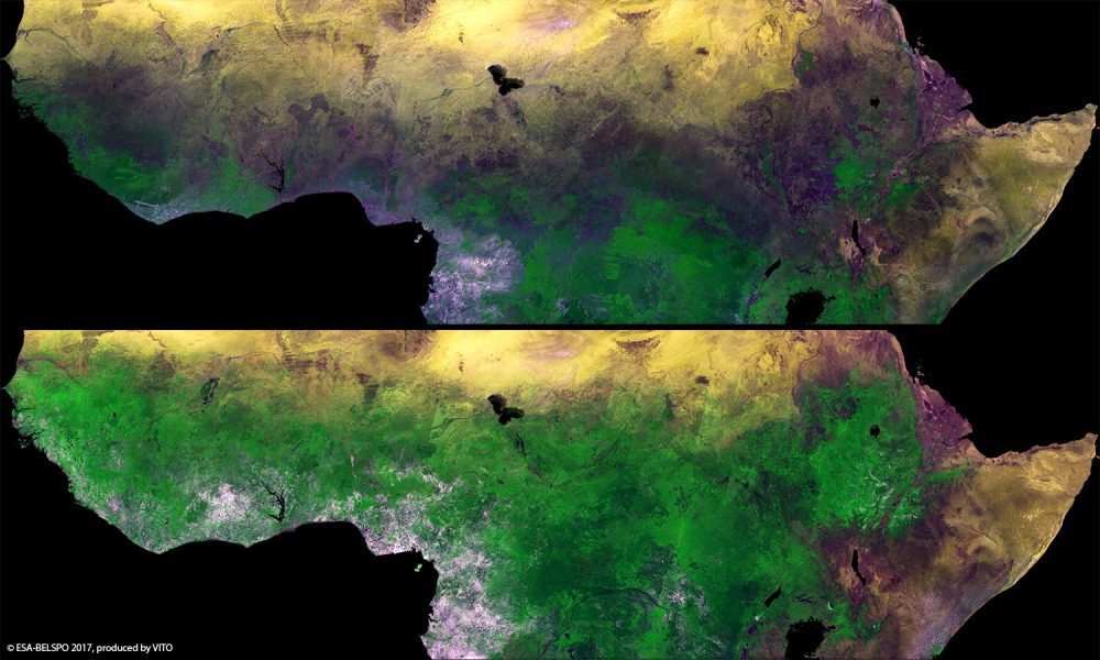
Proba-V Monitors African Sahel
The European Space Agency (ESA) Proba-V minisatellite recorded the seasonal changes in Africa's sub-Saharan Sahel, which stretches more than 5,000 kilometers across Africa, from the Atlantic Ocean (Senegal, Mauritania) to the Red Sea (Sudan).
ARABSAT Selects Kratos' End-to-End Network Management Solution To Scale Growing Satellite Ground Operations
SAN DIEGO - Kratos Defense & Security Solutions, Inc. (Nasdaq:KTOS), a leading National Security Solutions provider, announced today that the Arab Satellite Communications Organization (Arabsat), the leading satellite operator in the Middle East, has selected...
FAA Administrator Michael P. Huerta to Deliver Grand Opening Keynote Address at InterDrone
MELVILLE, N.Y. — BZ Media LLC today announced that Michael P. Huerta, administrator of the Federal Aviation Administration, will give the Grand Opening Keynote address at InterDrone, September 6 at 10:00 am. He will be joined at InterDrone by a high-level lineup of...
Geovation Programme Now Open to Location and Land Disruptors
A new generation of location and property data start-ups are to receive funding, business support and the strategic backing of Ordnance Survey (OS) and HM Land Registry (HMLR). The Geovation Programme is now accepting applications from start-ups using location and/or...
1Spatial Awarded Safe Software's Top Partner Award 2016
Sydney, Australia: 1Spatial, the spatial solutions provider, was recently awarded Safe Software’s ‘Top Partner Award 2016’ at the FME International User Conference in Vancouver, Canada. This recognises 1Spatial as a key collaborative partner working across the...
Explore the World's Geology with Getech's Interactive Maps
Getech, providers of natural resources exploration data and information expertise, has created two interactive ArcGIS Online maps that allow users to explore an increadible amount of geological information for any region across the globe. The first of the maps allows...
ILMF 2018 – Now Partnered with ASPRS!
Have you heard? The International LiDAR Mapping Forum (ILMF) and the American Society for Photogrammetry & Remote Sensing (ASPRS) Annual Meeting will take place together for the very first time in 2018! Taking place February 5-7, 2018 in Denver, CO this will...
