LONG BEACH, Calif. – Epson today announced it is shipping the two new ultra-sleek wide-format SureColor® T-Series plotters – the Epson SureColor T3170 24-inch desktop printer and the SureColor T5170 36-inch floor-standing printer. Featuring a clean and compact...
Vectorworks Releases 2019 Version of Its Award-Winning Design & BIM Software
Columbia, MD — Global design and BIM software solutions provider Vectorworks, Inc. announces the 2019 release of Vectorworks Architect, Landmark, Spotlight, Fundamentals and Designer, as well as BraceworksTM and Vision. With a focus on increasing design efficiency...
Nimbus VTOL V2 is Released
Foxtech Nimbus V2 is a upgraded version based on Nimbus Mapping Version, it is a Vertical Take-off and Landing airplane, in this version, we equip new 28kg high speed tilting servos, with the newly upgraded system, the plane can hover like a multicopter more steadily...
Teledyne Optech's Dr. Paul LaRocque to Deliver Address at ION GNSS+
Teledyne Optech is pleased to announce that Dr. Paul E. LaRocque, VP Special Projects, will be presenting at the ION GNSS+ technical meeting and showcase, to be held September 24-28, 2018 in Miami, Florida. In his presentation, titled A Lidar History: From Ship to Air...
East View Geospatial Partners with Space View for Reselling Satellite Imagery
MINNEAPOLIS, Minnesota, USA – East View Geospatial (EVG) is pleased to announce its new reseller partnership with Beijing Space View Technology Co., Ltd., a leading provider of satellite data and geospatial information services.  With this new partnership, EVG is...
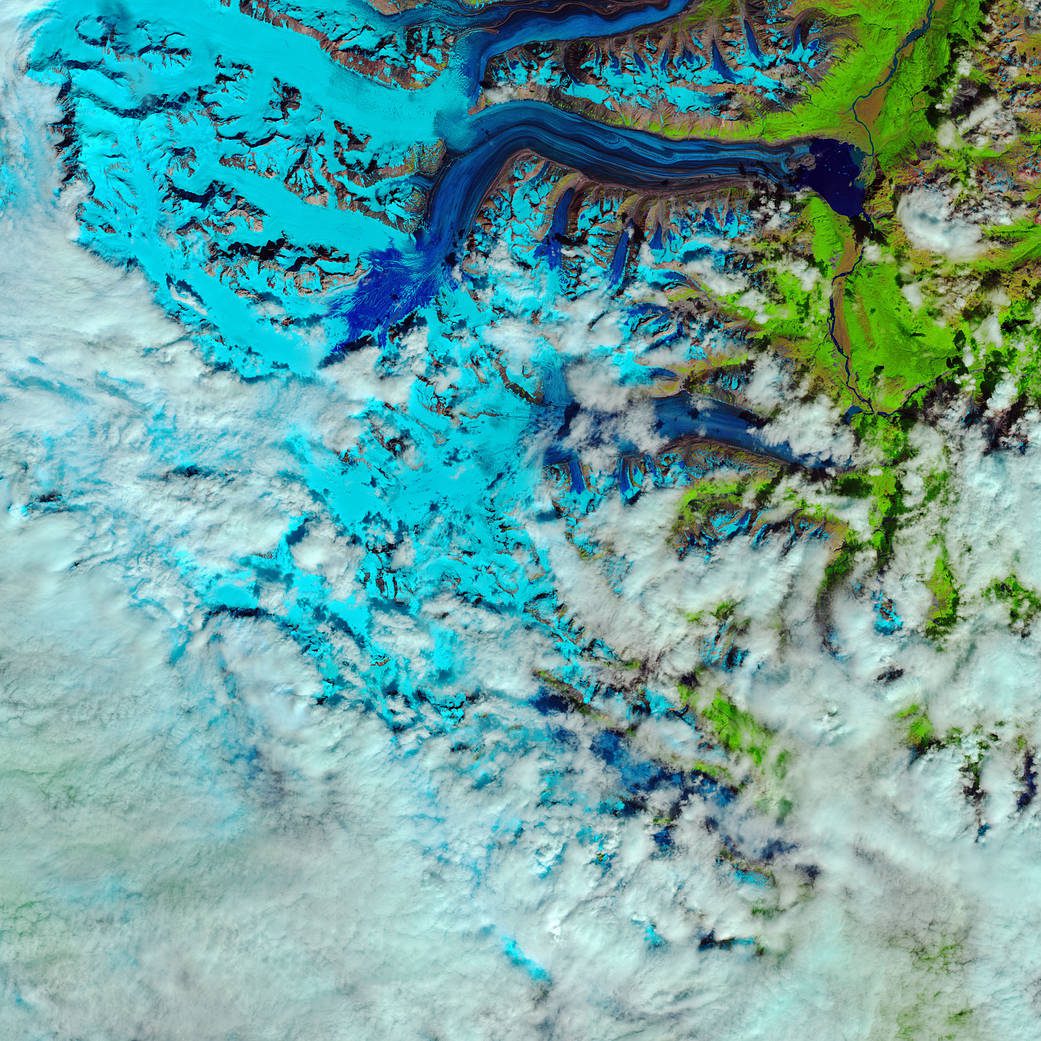
˜Snow Swamp' on Canada's Lowell Glacier
This false-color image shows the progression of the rapid snow melt in the Kluane National Park in the Yukon Territory.
Trimble Continues Evolution of Video Intelligence with Introduction of Intelliview and High-Definition Video Capture
HOUSTON - Trimble (NASDAQ : TRMB ) debuted today two enhancements to its Video Intelligence platform. These enhancements include the introduction of the Intelliviewâ„¢ feature and the availability of a new camera and digital video recorder (DVR) that capture...
MDA’s Satellite Antennas and Subsystems to Expand Access in Two Tele-communications Programs
MONTREAL -Â MDA, a Maxar Technologies company (formerly MacDonald, Dettwiler and Associates Ltd.), (NYSE : MAXR ; TSX: MAXR), reinforced its position as the leading provider of satellite antennas with over five decades of successful deployments in demanding...
Raytheon Strengthens Alliance with Commercial Satellite Company, HawkEye 360, to Further Enhance Data Analytics for Government Users
DULLES, Va.-Â Raytheon Company's (NYSE : RTN ) Intelligence, Information and Services business is collaborating with commercial small satellite company, HawkEye 360 Inc., as part of its ongoing focus to provide innovative commercial technologies and more precise data...
LTI Partners with Eos and Esri to Develop World’s First Laser Offset Solution That Transforms How Field Crews Collect Data
CENTENNIAL, Colo.: Three of North America's leading technology companies have partnered to create the world's first laser offset mapping solution, one that improves how field crews can safely and accurately capture data in hard-to-reach assets and in GNSS-impaired...
