ROSH HA'AYIN, Israel -Â Innoviz Technologies, a leading provider of high-performance, solid-state LiDAR sensors and perception software, announced today that it has raised $132 million in Series C funding. The round is marked by the entrance of new major investors...
Habitat for Humanity-North Central Georgia Recognizes InterDev with Two Awards for Homebuilding Sponsorship
ALPHARETTA, Ga.-Â InterDev, an Atlanta-area provider of information technology, security and geographic information systems (GIS) services, today announced it has been honored by Habitat for Humanity-North Central Georgia for its sponsorship and service in 2017 and...
Technology Leader Pontus Noren To Join GeoSpock's Board As Company Secures Further £2 Million Investment From Parkwalk Advisors
CAMBRIDGE, England - GeoSpock® – the extreme-scale spatial big data integration company that provides analytics, builds insight, and enables predictions across space and time – today announced the appointment of Pontus Noren to a Non-Executive role on its Board...
Mapbox and New Light Technologies Partner on Atlas Managed Service Offering
WASHINGTON - Mapbox and New Light Technologies, Inc. (NLT) today announced a strategic partnership to deliver Mapbox's on-premises solution, Mapbox Atlas, as a managed service offering to federal, state, and local governments. As demand grows for live, cloud-based...
Elastic Releases Elastic Stack 6.7 with New Maps & Uptime Solutions and the GA of Logs & Infrastructure Solutions, Elasticsearch SQL, and Canvas
MOUNTAIN VIEW, Calif.- Elastic N.V. (NYSE: ESTC), the company behind Elasticsearch and the Elastic Stack, announced the general availability of version 6.7 of the Elastic Stack. This release delivers two new solutions: Maps, for advanced, layered visualization of...
Pond5 and DJI Expand Premium Aerial Footage Collection With New Content From Around the World
Following last year’s much-heralded launch of thePond5 DJI premium footage collection, global content marketplacePond5andDJI, the worlds leading manufacturer of civilian drones and aerial imaging technology, have expanded the in-demand offering to include a wealth...
Innoviz Technologies Raises $132M in Series C Funding to Accelerate Solid-State LiDAR Production, Expand Team and Further R&D Efforts
ROSH HA’AYIN, Israel – Innoviz Technologies, a leading provider of high-performance, solid-state LiDAR sensors and perception software, announced today that it has raised $132 million in Series C funding. The round is marked by the entrance of new major...
Space Flight Laboratory to Build HawkEye 360 Next-Gen Microsatellite Cluster for Commercial Radio Frequency Geolocation
TORONTO, March 27, 2019 - Space Flight Laboratory (SFL) has been awarded the prime contract to develop the next generation cluster of formation-flying microsatellites for HawkEye 360 Inc. of Herndon, Va. The HawkEye Constellation, comprised of multiple clusters of...
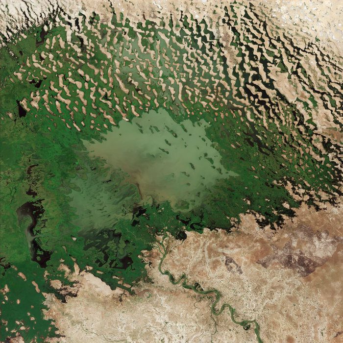
Lake Chad's Shrinking Waters
This image from the Copernicus Sentinel-2A satellite takes us over Lake Chad at the southern edge of the Sahara, where water supplies are dwindling.
GeoSpock and X-Locations collaborate to deliver next generation location data analysis in Japan
GeoSpock – the extreme-scale spatial big data integration company that provides analytics, builds insight, and enables predictions across space and time – announced a new partnership with X-Locations – the Japan-based location AI platform company. The companies...
