HOLLYWOOD, Fla.- NV5 Global, Inc. (the “Company” or “NV5”) (Nasdaq: NVEE), a provider of technology, conformity assessment, and consulting solutions, announced today that it has been awarded a three-year, $27 million contract by the California Department of...
PAWR Program Announces Dramatic Expansion of AERPAW Drone Testbed with Phase Two Launch
WASHINGTON -The Platforms for Advanced Wireless Research (PAWR) Project Office announces the significant expansion of AERPAW – the first wireless research platform to study the convergence of 4G/5G technology and autonomous drones – as it launches into...
Canon Electronics Successfully Launches CE-SAT-IE Satellite into Orbit
Melville, NY - Canon U.S.A., Inc., a leader in digital imaging solutions, is pleased to announce the CE-SAT-IE, micro-satellite developed and manufactured by Canon Electronics, entered orbit and communicated with the ground station installed at Canon Electronics’...
East Herts District Council selects Cadcorp for advancing digital planning services
Cadcorp customer awarded DLUHC Digital Planning Programme Funding for innovating planning services East Herts District Council, (EHDC) has been awarded funding from the Department for Levelling Up, Housing and Communities (DLUHC) Digital Planning Programme Funding...
Smarter AI for All: Lenovo Unveils Hybrid AI Solutions that Deliver the Power of Tailored Generative AI to Every Enterprise and Cloud in Collaboration with NVIDIA
SAN JOSE, Calif.-Today, at NVIDIA GTC, a global AI conference, Lenovo announced new hybrid AI solutions, built in collaboration with NVIDIA, that deliver the power of tailored generative AI applications to every enterprise and cloud, bringing transformational...
ModalAI Expands Suite of NDAA-Compliant Drone Components to Advance U.S. Drone Industry
SAN DIEGO- ModalAI, a Blue UAS Framework drone and autopilot manufacturer, celebrated for its 16g autonomous UAS autopilot VOXL 2, today announced availability of NDAA-compliant drone accessories. ModalAI is expanding its technology offerings with the...
Corcovado Geosub Ltda looks to Kongsberg Discovery to supply cNODE Transponders for environmental monitoring
Corcovado Geosub Ltda today signed a multimillion-dollar contract with Kongsberg Discovery for advanced seabed monitoring equipment. The agreement, for the delivery of cNODE Sensor Logging Transponders, will allow Corcovado to conduct long-term environmental...
HEAVY.AI Introduces HeavyIQ, Delivering Powerful Conversational Analytics Focused on Location and Time Data
HeavyIQ leverages Natural Language Processing to enable organizations to easily explore their massive data sets and quickly generate advanced visualizations SAN JOSE – March 19, 2024 – HEAVY.AI, innovator in advanced analytics, today announced HeavyIQ. HeavyIQ...
Trimble and Radiodetection Combine Survey-Grade Positioning with Underground Utilities Locating Measurement Workflows
Trimble Catalyst Now Integrates with Radiodetection’s RD Map+ Application and Precision Locators to Bring Survey-Grade Accuracy to Utility Workflows in North America WESTMINSTER, Colo. — Trimble (NASDAQ: TRMB) and Radiodetection announced today a collaboration to...
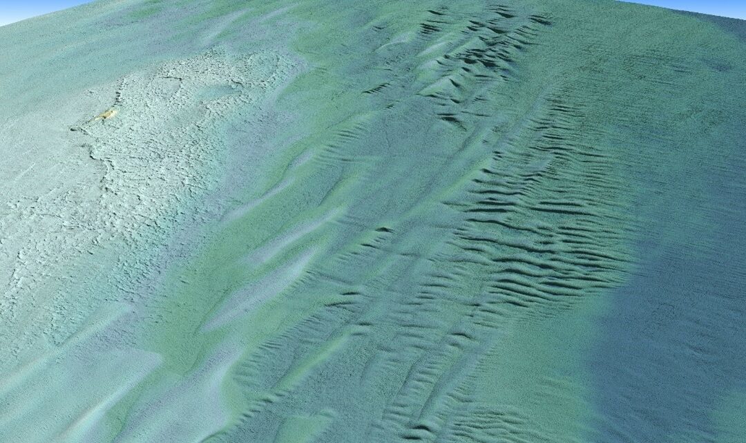
Lidar Sensors Help Complete NOAA’s Great Lakes Coastal Mapping Project
Tetra Tech Inc. used a Teledyne Optech CZMIL SuperNova Topobathymetric lidar system to successfully complete a project for the National Oceanic and Atmospheric Administration (NOAA) to update all its bathymetric maps in the Great Lakes region, which includes refined maps of the marine ecology.
