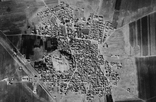
A study of declassified Cold War spy satellite photos has tripled the number of known archaeological sites across the Middle East, revealing thousands of ancient cities, roads, canals and other ruins.
A study of declassified Cold War spy satellite photos has tripled the number of known archaeological sites across the Middle East, revealing thousands of ancient cities, roads, canals and other ruins.

According to the Federal Aviation Administration, the incident took place on March 22, 2014, and involved U.S. Airways Flight 4650 flying from Charlotte, N.C., to Tallahassee, Fla.
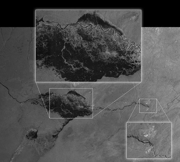
One of the European Space Agency's Sentinel-1 satellite's first images was crucial in helping Namibian authorities decide how to respond to a serious flood.
Redlands, Calif., April 29, 2014—Esri announced today that the Esri Climate Resilience App Challenge 2014 is now open worldwide to developers of all types (government, technology firms, academic institutions, not for profits, startups, and individuals). This contest...
Washington, D.C., April 30, 2014—A NASA spacecraft designed to make precise measurements of carbon dioxide in Earth’s atmosphere is at Vandenberg Air Force Base, Calif., to begin final preparations for launch. The Orbiting Carbon Observatory-2 arrived Wednesday at...
Fitchburg, Mass., May 5, 2014—In leading the industry with spectral imaging innovation and responding to strong demand, Headwall has released the Hyperspec® VNIR-SWIR sensor for general availability. The high-performance airborne sensor is versatile and covers the...
Lausanne, Switzerland, April 30, 2014—Precision agriculture meets cutting-edge UAV technology with Version 1.1 of Pix4Dmapper! This new version comes with an integrated Index Calculator that allows users to create meaningful maps from any multi-spectral sensor and...
Washington, D.C., April 28, 2014—TerraGo announces the launch of new product suite, TerraGo Workgroups. TerraGo Workgroups bundles TerraGo Publisher® for ArcGIS®, TerraGo Composer® and TerraGo Toolbar® products together so GeoPDF maps and imagery can be easily...
Graz, Austria, April 30, 2014—XEOS Imaging has contracted with Microsoft’s UltraCam business unit and subsidiary to purchase an UltraCam Falcon digital aerial camera system to serve customers throughout North America. The UltraCam Falcon is offered in two image...
Hallowell, Maine, April 29, 2014—Blue Marble Geographics (www.bluemarblegeo.com) is pleased to announce that Blue Marble President Patrick Cunningham has been appointed to the Maine Library of Geographic Information Board also known as the GeoLibrary Board. Blue...
