Graz, Austria, May 14, 2014—GeoAir has contracted with Microsoft’s UltraCam business unit and subsidiary to purchase an UltraCam Falcon digital aerial camera system and UltraMap workflow software to handle large volumes of data efficiently. GeoAir operates...
Insitu Pacific Demonstrates Fire Management Assistance with ScanEagle Unmanned Aircraft
BRISBANE, Australia, May 13, 2014—Insitu Pacific, the Australia-based subsidiary of Insitu Inc., today announced it recently conducted a successful demonstration for the New South Wales Rural Fire Service (NSW RFS) using the ScanEagle unmanned aircraft system (UAS)....
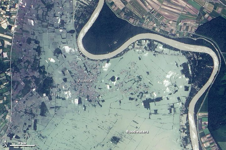
Balkans Flooding Affects 3 Million People
NASA's Earth Observing-1 satellite shows how three months' worth of rain in just three days has caused swollen rivers and devastating flooding across the Balkan region of Europe.
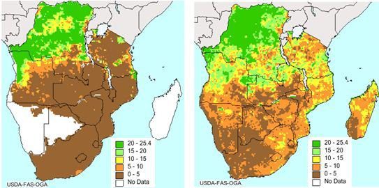
ESA Satellite Helps Boost Food Security
The European Space Agency's Soil Moisture and Ocean Salinity mission has reached beyond its water cycle mission to predict drought and improve crop yield in regions prone to famine.
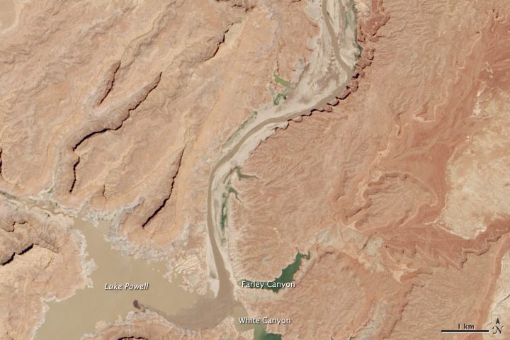
Satellite Shows Half-Empty Lake Powell
Lake Powell's water levels fluctuate depending on how much water flows in from snow and rain and how much flows out to meet needs, but it has been dry in all but three of the last 14 years.
Nigeria’s Neglected Drones Can’t Search for Missing Girls
As U.S. planes try to locate more than 200 girls kidnapped by Islamist group Boko Haram, Nigeria's own unmanned aircraft can't join the search”poor maintenance has them grounded.
Apache-UAV Teaming Combines Best Capabilities of Man, Machine
NASHVILLE, May 8, 2014—Apache helicopters, teamed with Gray Eagle and Shadow unmanned aerial vehicles, are a winning combo, according to Col. Thomas von Eschenbach. Apache AH-64E models, teamed with unmanned aerial vehicles, known as UAVs, are now increasingly...
Blue Marble Releases Global Mapper v15.2 with New Automation for Creating Features
Hallowell, Maine, May 19, 2014—Blue Marble Geographics (bluemarblegeo.com) is pleased to announce the release of Global Mapper version 15.2. This minor release features new functionality to automate the “New Feature Creation†process, as well as the addition of...
Leica Zeno CS25 Plus and CS25 GNSS Plus Speed up GIS Asset Collection and Management
Heerbrugg, Switzerland, May 12, 2014—Leica Geosystems releases the Leica Zeno CS25 plus and CS25 GNSS plus, the next generation of its popular and durable 7†tablet computer for GIS data collection. Both handheld tablets offer significantly improved overall...
Saab Skeldar UAS Lands a Further Key ISR Capability
STOCKHOLM, May 8, 2014—The latest addition to Skeldar’s ISR capabilities is its integration with another fielded Saab product, the Multi-Sensor Intelligence Cell (MSIC). The MSIC is a flexible ground-based system developed by defence and security company Saab to...
