ROCHESTER, N.Y., June 2, 2014—Exelis ( NYSE: XLS ) has been awarded a contract by NASA worth up to $208 million to build the Radiation Budget Instrument (RBI) , a satellite payload that will improve scientific understanding of climate change. The contract includes...
First UltraCam Eagle in Australia Purchased by Advance Aviation Group
Graz, Austria,June 3, 2014—Advance Aviation Group Pty Ltd (AAG), a Transwonderland Limited company, has contracted with Microsoft’s UltraCam business unit and subsidiary to purchase the first UltraCam Eagle “ultra-large†digital aerial camera to be delivered...
Lockheed Martin Selected to Provide U.S. Air Force with Space Fence Radar to Safeguard Space Resources
MOORESTOWN, N.J., June 3, 2014—The U.S. Air Force has awarded Lockheed Martin [NYSE: LMT] a $914 million contract to improve the way objects are tracked in space and increase our ability to prevent space-based collisions. Lockheed Martin’s Space Fence solution, an...
OGC Announces New Domain Working Group for Mobile Location Services
June 4, 2014—The Open Geospatial Consortium (OGC®) membership has formed the Mobile Location Services Domain Working Group (DWG). The new group will replace both the existing Mass Market and OpenLS working groups. In an effort to better reflect the current...
TerraGo Partners with Beijing Space View Technology to Support Growth in China
Washington, D.C., June 10, 2014—TerraGo, a leading provider of geospatial collaboration software, announced today a partnership with Beijing Space View Technology to help meet growing demand in China and better serve customers in that region. Beijing Space View...

Google Buys Skybox Imaging for $500 Million
Google agreed on June 10, 2014, to buy Skybox Imaging, a satellite imagery provider, as the technology giant continues its lofty ambitions for its Internet offerings.

FAA Approves First U.S. Commercial Drone
The Federal Aviation Administration (FAA) will permit energy company BP and unmanned aircraft system (UAS) manufacturer AeroVironment to fly a Puma AE UAS for aerial surveys in Alaska.

Sanborn Joins Battle against California Drought
California Water Service Company selected The Sanborn Map Company to leverage its geospatial data collection and remote sensing expertise against the state's severe drought.
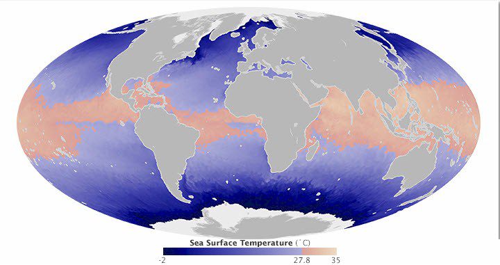
Satellites Take the Temperature of the Hurricane Pool
According to the meteorological calendar, hurricane season began on May 15, 2014, in the Eastern Pacific Ocean and on June 1, 2014, in the Atlantic Ocean. But are the oceans ready for the season?
Applanix, American Aerospace Advisors Announce Mapping Solution for Unmanned Aerial Vehicles
Orlando, Fla., May 13, 2014—Applanix Corp and American Aerospace Advisors Inc (AAAI) today announced  an OEM supply agreement that will incorporate Applanix’ industry-leading direct georeferencing technology into AAAI’s unmanned aerial platforms. The...
